Persistently small from the south

Southeast Queensland and Northern New South Wales Surf Forecast by Ben Matson (issued Monday 21st June)
Best Days: Entire period: small pulsely south swells for exposed beaches in Northern NSW. Not much happening in SE Qld apart from Tues AM.
Recap: Large and windy from the south was the main item on the weekend’s menu. Only protected locations in Northern NSW offered anything rideable rideable, with the Gold and Sunshine Coast points picking up much smaller but far more manageable waves both days.
The weekend’s swell started to ease late Sunday and has trended steadily downwards all day today. However, a new E/SE swell arrived across southern NSW around lunchtime today, and provided a noticeable kick in size this afternoon, with 3-4ft waves on offer at exposed Sydney beaches. It now seems that this (SE) swell is starting too push into Northern NSW and SE Qld too, with some small but distinct lines of swell observed on our surfcam at The Pass, and also some increasing activity at D’Bah.
Annoyingly for me, I mentioned this swell in last Wednesday’s notes but excluded it on Friday because the models had downgraded the responsible low, and I assumed that any energy from this system would not be noticeable underneath the easing S/SE swell.. which was wrong!
Interestingly, even assessing the ASCAT passes from Saturday (when the low reached maturity) doesn’t signify anything major.. the fetch was short lived, was working on a relatively benign ocean state, and it was off-axis from our swell window for the most part. In any case this event is likely to reach a peak overnight and will trend downwards through Tuesday.
This week (July 22-25)
We’re staring down the barrel of an extended period of small flukey swells for the East Coast, which should be manageable for exposed south facing locales in Northern NSW. But the prognosis doesn’t offer much hope for SE Qld surfers.
Our current SE swell is expected to peak overnight but we should still see some leftovers sets in the 2-3ft+ range across exposed beaches in Northern NSW early Tuesday morning before it continues a downward trend. Wave heights will be smaller in SE Qld, especially across the points, so aim for a south facing beach to maximise your size. Winds should remain light all day so conditions should be quite good on top.
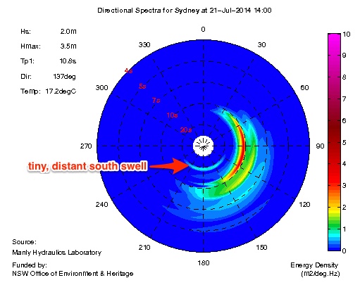
There’ll also be some distant southerly groundswell in the mix (only at south facing beaches in Northern NSW), from a deep polar low that traversed the Southern Ocean south of the continent late last week, and generated good waves for Vic/SA/Tas this morning. The Sydney buoy has already picked up the leading edge of this swell (Tp 19 seconds, see spectral chart below), but I’d be surprised if there was much more than couple of very inconsistent feet at south swell magnets.
These swells will then ease throughout Wednesday leaving small residual energy across most beaches. Another front racing up through the lower Tasman Sea today is generating some sideband S/SE energy that’ll maintain small inconsistent waves at south facing beaches very late Wednesday (across the Lower Mid North Coast) and early Thursday (remaining North Coast). At this stage I don’t think we’ll see much more than an occasional 2ft to maybe 3ft set at the best performing south facing beaches, and it’ll be much smaller elsewhere. Don’t expect much size north of the border either. Again, light winds are expected in most areas (generally out of the south) so conditions should remain OK.
Thursday’s swell will ease on Friday, only to be replaced by a stronger pulse of distant energy during the day, thanks to a strong polar low developing well to the south of Tasmania on Tuesday. At this stage current expectations are for occasional 2-3ft+ sets at south facing beaches building from mid-morning onwards (probably not reaching the Far North until well after lunchtime), with generally light winds on hand. I’ll take a closer look at this on Wednesday.
One other minor system to revisit in Wednesday's notes - a small surface trough pushing off the coast on Thursday that may spin up a small, brief fetch of N’ly winds in close proximity to the Byron region that evening. This has the potential to whip up a small NE windswell for Friday at exposed north facing beaches (now there’s a term that doesn’t get used very often!) in SE Qld and the Far Northern NSW, however I’d only rate it a low probability right now.
This weekend (July 26-27)
I’m expecting more of the same small, flukey south swell to persist all weekend across the southern NSW coast.
Additionally, a broad Tasman High looks like it’ll momentarily strength a modest belt of trades within SE Qld’s eastern swell window on Friday and Saturday, which may kick up a small short range E'ly swell around Sunday. I’m not expecting much from this though, unless we see an upgrade in the models.
The only other notable feature for the weekend is a broad surface trough that’s currently expected to push across from Victoria and out into the Tasman Sea during Saturday, and subsequently develop a modest S/SW fetch parallel to the South Coast.
This may in turn generate a small to moderate short range south swell for the Mid North Coast Sunday - but again, confidence is not high on any quality (or size) at this early stage. Let’s assess the data more comprehensively on Wednesday.
Longer term (July 28 onwards)
Nothing of major interest lighting up the long range charts at the moment, mainly due to an amplifying Long Wave Trough to the SW of Western Australia. Because the downward flank of this upper level system will be positioned across the eastern half of Australia's longitudes, the storm track will be focused away from our southern swell window. And on top of that our eastern swell window remains devoid of any major activity, with the high pressure belt sitting quite north in latitude (as is common at this time of year).
This all suggests we could be looking at an extended period of small and/or flukey, short lived swell events for the next couple of weeks. So, get your small wave quiver ready to go, as it’s gonna get a lot of attention in the next little while.
Comments
Is there a way of looking at all of the photos from the report, on a Samsung with chrome?
No, I don't think so. The mobile experience isn't great right now but we're working on a solution.
Ahhh hang on, i brought up the menu, then selected 'request desktop site'. Then the arrows appear besides the photos
When are those long wave troughs gonna move between Oz and NZ....?
Mid August..? September...?
Never this Winter...?
Gee
Huh Welly? We just had one last week. Didn't line up very well for NZ though.
Yeah Ben saw that one but didn't stall like the last few under OZ........?
Cheers
Indo's going to see all the action from Sunday into early August..
www.swellnet.com/reports/forecaster-notes/bali-sumbawa-east-java/2014/07...
craig, this thurs'/fri'/sat' will be good on the "deliverance" coast down here..... That's if 4/3, bootys, gloves, hoods, great whites, and rocks are your thing.....
Indeed it will!
Ben, please speak to king Neptune about putting swell ON for week commencing 28th.
Much love.
I'll try my best. But I think we exhausted our annual pumping-swell allocation in early autumn!