Thursday is the pick of the forecast period

Southeast Queensland and Northern New South Wales Surf Forecast by Ben Matson (issued Monday 7th June)
Best Days: Tues/Wed: small waves at open beaches with generally good winds (not much in SE Qld). Thurs: solid SE groundswell in the south (smaller in the north, esp SE Qld) with offshore winds. Fri: fun, easing swell with good winds (only small in SE Qld). Sat: small fun waves across most open beaches with good winds.
Recap: Small, fun intermittent S/SE swells across the weekend and into this morning, with generally good winds - although Saturday afternoon did see a weak NE sea breeze in some locations, others saw light E/SE winds Sunday afternoon. A marginally bigger S/SE swell has filled in today but again it’s only favouring south facing beaches in Northern NSW. SE Qld has remained tiny right throughout this period due to the prevailing southerly swell direction.
This week (July 8-11)
We’ve got a pretty good forecast coming up for Northern NSW (and to a lesser degree SE Qld), however the main juice isn’t due until Thursday. Until then we’re looking at small, residual energy from the SE that’ll really only favour exposed beaches in Northern NSW.
These pulses will originate from two modest fetches related to the primary system that generated today’s small new swell, however they’re both a little weaker and consequently won't deliver much size across most beaches. Light to moderate W’ly tending NW winds on Tuesday will freshen from the N/NW on Wednesday, so aim for a northern corner for the most size and the cleanest waves.
Don’t expect much sized north of the border either, away from the swell magnets. We really are in the midst of a typical winter weather progression and whilst bloody annoying, these kinds of lengthy flat spells are par for the course at this time of year.
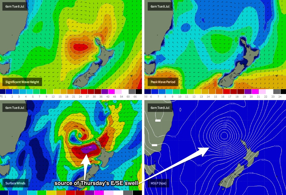
Where we need to focus our attention over the coming 24-48 hours is the waters north-west of New Zealand. As I’ve been discussing since last Wednesday, the broad trough occupying the central Tasman Sea stretches all the way up to New Caledonian longitudes, and a new low pressure system is expected to form mid-way between New Caledonia and New Zealand tonight, before tracking south to a position off the west coast of the North Island during Tuesday.
As this happens, the low will push up against a strong, stationary high pressure system to the south-east of New Zealand, resulting in a strengthening E/NE thru’ E’ly airstream that’ll reach gale to storm force through Tuesday and early Wednesday (see chart below), generating a heavy swell for the southern NSW coast on Thursday.
You’ll notice the previous sentence referenced ‘southern NSW coast’. Yes, this swell is aimed away from Northern NSW, so size will become smaller with increasing northerly latitude - and especially so Southeast Queensland. And one of the really fun parts about surf forecasting is estimating exactly where these size thresholds will cut off, which is not an easy task, somewhat exacerbated by a secondary E/NE fetch stretching NE of New Zealand - just outside the swell shadow of the North Island - that’ll contribute some background energy towards the end of the week.
Right now (included for those of you who can manage a road trip) I’m expecting around 6-8ft in the southern parts of NSW, grading to 5-6ft across Wollongong/Sydney/Newcastle, of which we’ll probably see only slightly smaller waves in the Mid North Coast (i.e. Seal Rocks to Coffs), say 4-5ft, with the direction tending SE.
North of Coffs Harbour, I suspect wave heights will taper off to 3-4ft through to about the Tweed Coast on Thursday, with smaller surf in the 2ft range for most Gold and Sunshine Coast beaches (maybe a few bigger 3ft waves at exposed south facing beaches north of the border). Moderate W’ly winds should keep conditions clean at the beach breaks during this time, and wave heights will slowly taper off into Friday.
The only other source of new swell for the end of the week has potential for the Mid North Coast (Seal Rocks to about Coffs). A healthy band of W/SW gales exiting the waters of eastern Bass Strait on Thursday are expected to generate a similarly flukey south swell as per what we saw a couple of times, a week or two ago. Exposed south swell magnets in this region may pick up some 3ft sets late Friday afternoon day, which when mixed in with the easing SE swell, should provide some fun beachbreaks to finish off the week. More on this in Wednesday’s update.
This weekend (July 12-13)
The secondary E/NE fetch immediately NE of New Zealand mid-week will supply the coast with small E’ly swell into the weekend. No great size is expected but most open stretches should see (very) inconsistent 2ft sets both days.
Friday’s late arrival of south swell will probably hold out into Saturday morning before easing during the day, and light offshore winds should keep conditions clean.
On Sunday we’re looking at a reasonable chance for a brisk southerly change to make its way across the coast. This should also kick up a punchy short range south swell for the afternoon (only for south facing beaches) - however local winds will render exposed spots quite bumpy.
Anyway, let’s take a closer look on Wednesday.
Next week (July 14 onwards)
No real changes to the storm track pattern that’s dominated our swell window for much of the last month or so. We’re looking at plenty of south swell early next week, and long range modelling suggests this theme will continue through the middle to latter part of next week, albeit from more distant sources in the South Ocean. I’ll have more idea on the specifics in Wednesday’s update.