Fun swell Friday, with a larger SW groundswell for Sunday/Monday

South Australian forecast by Craig Brokensha (issued Wednesday April 2nd)
Best Days: Both coasts Friday morning, South Coast for the keen Saturday, South Coast Sunday, Mid Coast Monday morning, South Coast Tuesday morning
Features of the Forecast (tl;dr)
- Smaller tomorrow with strong S winds
- Moderate sized W/SW swell Fri with variable tending locally offshore winds ahead of sea breezes
- Reinforcing SW swell Sat with moderate S/SE winds (SE on the Mid), easing and tending SW into the PM
- Large SW groundswell building later Sun, peaking Mon
- N tending strengthening W/NW winds Sun, S/SW Mon (S/SE early on the Mid)
- Easing swell Tue with E/NE-NE winds
Recap
The South Coast offered improving surf through yesterday with conditions cleaning up a little better than expected shortly after dawn, more so into the early afternoon under an E/NE-NE breeze. A new pulse of swell offered 3-4ft sets before easing back from 2-3ft this morning under light winds again.
The Mid Coast has been tiny and mostly to 0.5ft with the odd 1ft’er in the mix.
This week and weekend (Apr 3 - 6)
Tomorrow looks like a lay day as a trough brings a S/SW change this afternoon, followed by stronger S’ly winds tomorrow but with no decent swell.

Friday however is looking super fun for the Mid Coast as our moderate sized mid-period W/SW swell fills in. This swell was generated by a healthy frontal system projecting towards Western Australia earlier this week and should provide good 2ft waves across the Mid Coast all day, easing back from 1-1.5ft Saturday.
A slightly better aligned SW swell is due for the South Coast at the same time, generated by a strong polar frontal system that’s currently south of Western Australia and this should provide building sets to 3-4ft across Middleton into the afternoon.
Local winds look good for both coasts Friday morning as the trough moving through tomorrow clears temporarily, bringing variable N/NE winds down South and a light E/SE offshore on the Mid Coast ahead of freshening sea breezes.
As the swell eases on Saturday, winds are due to shift back to the S/SE creating bumpy conditions down South while the Mid will be clean under a SE’ly but with the tiny, easing swell. Winds are only due to be light into the afternoon as an approaching front (linked to a significant Southern Ocean cold break) moves in, and some mid-period S/SW swell should maintain 3-4ft sets across Middleton all day.
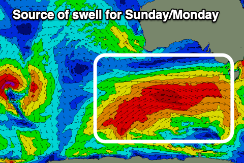
Now, looking at the Southern Ocean frontal progression itself, this will form under the influence of a strong node of the Long Wave Trough pushing across the south-east of the country.
We’re set to see various fetches of gale to at times severe-gale W-W/SW winds generated through our south-western swell window from Friday evening through the weekend, generating building levels of SW groundswell that look to peak through later Sunday/Monday.
Building sets to 5-6ft are due later Sunday across Middleton, peaking Monday morning to a similar size with the Mid Coast likely coming in at 1-1.5ft later Sunday, peaking to 1-2ft on Monday.
Winds on Sunday ahead of the swell look great for the South Coast and N’ly offshore along with 4ft or so of swell, while strengthening W/NW winds are due into the afternoon ahead of a late W/SW change.
This change will leave S/SW winds in its wake on Monday, with the Mid Coast possibly seeing an early S/SE breeze, cleaner Tuesday across both regions as the swell eases.
Longer term we’ve got some good, long-range SW groundswell on the cards for later next week and weekend, but more on this Friday.
Comments
I heard there were heaps of dead fish at KI anyone? Been out western beaches lately are they open and ok now?