Fun couple of days down South

South Australian Forecast by Craig Brokensha (issued Friday March 29th)
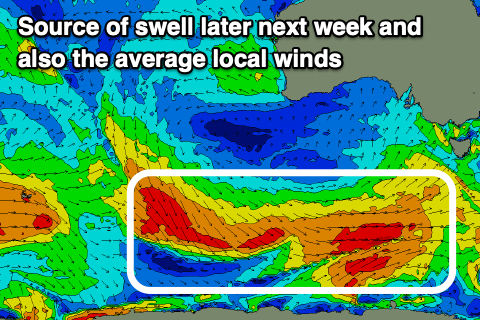
Best Days: South Coast today, tomorrow and Sunday, South Coast next Friday
Features of the Forecast (tl;dr)
- Small, inconsistent mid-period SW swell for this afternoon, easing tomorrow morning
- Reinforcing SW groundwell tomorrow PM and Sun AM, fading into Mon
- Light N winds tomorrow AM ahead of weak sea breezes, variable Sun AM ahead of weak sea breezes
- Light W/NW tending W/SW-SW winds later AM Mon
- Strong W/SW tending SW then S/SW winds Tue with some building windswell
- Small-moderate sized mid-period S/SW swell Wed with mod-fresh S/SE tending S/SW winds
- Moderate sized S/SW swell Thu/Fri with S/SE winds Thu, light E/NE-NE Fri AM
Recap
Conditions were lumpy but OK yesterday morning down South with plenty of swell hanging in the 3ft range, workable into the afternoon with sea breezes. The Mid Coast lingered in the tiny 1ft range.
Today we've got smaller surf down South with lumpy conditions under a light offshore wind, best on the magnets. Some new mid-period SW swell has since kicked up a bit more size as winds remain offshore (below).

Head-high sets late this morning
This weekend and next week (Mar 30 – Apr 5)
As touched on earlier in the week, the coming outlook will favour the South Coast with light morning winds and small pulses of background S/SW swell.
The Mid Coast will be mostly tiny to flat with some background W/SW swell energy for Sunday/Monday not likely to top 1ft.
Back to the South Coast, and a healthy though relatively weak fetch of strong W/NW winds east of the Heard Island region earlier this week should produce a lift in size to an inconsistent 2-3ft across Middleton this afternoon (it looks to be in already), easing from a similar size tomorrow morning.

Into the afternoon tomorrow, a flukey pulse of SW groundswell, spreading radially off a poorly aligned fetch of NW gales projecting towards the polar shelf should maintain inconsistent 2-3ft sets across Middleton, easing from a similar size Sunday morning.
Local winds will be great tomorrow and light N'ly ahead of relatively weak sea breezes, variable Sunday morning, again only giving into relatively weak sea breezes.
Monday morning as the swell fades from 2ft max on the sets looks clean with a light W/NW offshore, shifting W/SW-SW later morning as a trough starts moving in from the west.
The trough is due to deepen into a stronger low on approach, bringing stronger W/SW tending SW winds Tuesday, shifting S/SW through the afternoon.
This will kick up some small, weak local windswell across both regions, mixed in with some small, new mid-period S/SW swell from weak polar frontal activity to the south of the country Sunday through Tuesday.
The windswell looks similar in size to the S/SW energy, coming in around 3ft+ across Middleton with 1ft waves in the gulf Wednesday under moderate to fresh S/SE-S/SW winds.
Come Thursday/Friday, some slightly stronger S/SW energy is due from stronger polar frontal activity south of us mid-week, but S/SE winds will create poor conditions on the South Coast, improving Friday as winds hopefully shift E/NE-NE in the morning. Size wise Middleton should be around 4ft or so with tiny waves inside the gulf.
Next weekend should be fun across the South Coast with light N'ly winds and moderate levels of swell but we'll confirm this Monday. Have a great weekend!