Trickier period to nail down a surf

South Australian Surf Forecast by Craig Brokensha (issued Monday 12th)
Best Days: Tomorrow morning South Coast, Mid Coast for the keen Thursday morning, South Coast for the keen Thursday and Friday mornings, Saturday morning South Coast
Features of the Forecast (tl;dr)
- Small, background S/SW swell tomorrow AM with N/NW winds ahead of a strengthening S/SW change by late AM
- Moderate sized, weak S/SW swell Wed with gusty S winds
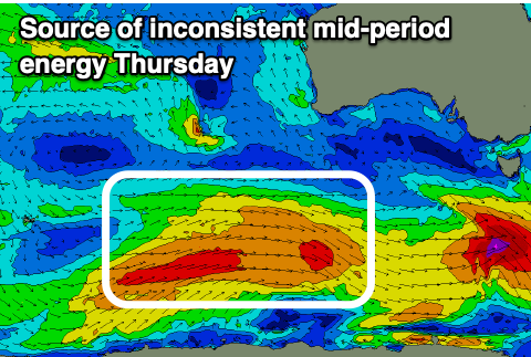
- Stronger, inconsistent SW swell Thu with E/SE tending S/SE winds
- Easing swell Fri with E/NE tending S/SE winds
- Smaller, inconsistent SW groundswell Sat with light N/NE tending S/SE winds
- Smaller Sun with S/SE winds
Recap
Saturday started bumpy and slow but a strong pulse of S/SW groundswell for the afternoon kicked in, best yesterday morning with cleaner conditions and easing surf from the 4ft range. The swell was too south for the Mid Coast and effectively flat.
This morning the surf was clean again with smaller, 2ft leftovers, though a trough has since brought a S'ly change.
This week and weekend (Feb 13 - 18)
Following some good to great days of surf the past couple of weeks, the outlook is slower into this period thanks to all the action being focussed more into the East Coast.
Persistent high pressure and marginal swell generating systems will see average winds and nothing overly special size wise.
Tomorrow looks like a nice window for a surf with a small pulse of mid-period S/SW swell though only to the 2ft+ range max across Middleton but with N/NW offshores, giving into a S/SW change later morning so surf early.
This change will be linked to a broad but weakening polar front pushing up and under us, bringing a low quality increase in mid-period swell Wednesday to 3ft+ or so, 1-1.5ft on the Mid Coast. The models are incorrectly combining swells here and over-forecasting the size.
Some stronger, mid-period energy generated by the earlier stages of the frontal system on the polar shelf should produce stronger sets to 3ft to occasionally 4ft on Thursday, with the Mid Coast easing from 1-1.5ft, smaller into Friday an dropping back from 3ft across Middleton.
Winds will unfortunately be average Wednesday and gusty from the S'th, better Thursday for the Mid Coast and E/SE in the morning, with an outside chance for light E'ly winds for a period down South.
Friday looks a better chance for this with a morning E/NE breeze, freshening from the S/SE during the afternoon so get in before lunch.
The weekend looks cleaner and peaky for a surf but smaller with background levels of easing S/SW swell, one generated by a strong but short-lived and distant polar low firing up around the Heard Island region today. This should provide inconsistent 2-3ft sets across Middleton Saturday with morning offshores ahead of sea breezes, smaller Sunday with a possible moderate S/SE onshore.
More on this Wednesday.