Large surf for the weekend but with dicey winds

South Australian Surf Forecast by Craig Brokensha (issued Friday 9th)
Best Days: Sunday South Coast, Monday morning South Coast, dawn Tuesday for the keen South Coast, Mid Coast Thursday morning for tiny runners
Features of the Forecast (tl;dr)
- Large S/SW groundswell buiding tomorrow afternoon with fresh SE tending S/SE winds
- Steadily easing S'ly swell Sun with variable E/NE-NE tending S/SW winds
- Small, fading surf Mon with N/NE tending SE winds
- Small, mid-period S/SW swell Tue with early NW winds, shifting S/SW mid-AM
- Building mid-period SW swell Wed with S/SE winds, peaking Thu AM with SE tending S/SE winds
Recap
Average, onshore but surfable waves across the South Coast yesterday, poor this morning, tiny and effectively flat across the Mid Coast.
This weekend and next week (Feb 10 - 16)
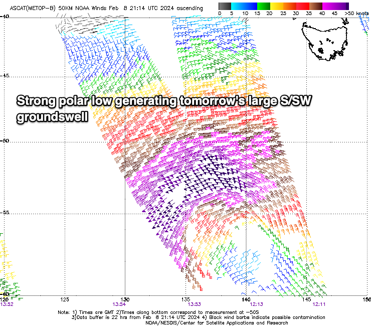
Looking at the weekend ahead and our large spike of S/SW groundswell due tomorrow afternoon is still on track, with a strong polar low firing up to the south-west of Tasmania yesterday.
A great fetch of severe-gale to storm-force winds have been projected through our southern swell window, with the low now slowly weakening while pushing east, out of our swell window today.
An arrival time is slated for later morning, with a strong kick in size to 5-6ft due across Middleton into the afternoon, 1ft or so on the Mid Coast but with gusty SE winds that will shift S/SE into the afternoon.
The swell will ease rapidly into Sunday thanks to the low moving under Tasmania today, with easing sets from 3-4ft across Middleton with tiny surf in the gulf.
Local winds look favourable and more variable Sunday morning, likely tending E/NE-NE before S/SW winds kick in. It won't be perfect but it should be fun through the morning.
A N/NE offshore is then due to create cleaner conditions on Monday but with small, fading 2ft sets.
Into Tuesday, a small pulse background S/SW swell is due, generated by unfavourably aligned fetches of W/NW-NW winds, following the low linked to tomorrow's swell. This should maintain slow 2ft sets across Middleton Tuesday with early offshore winds ahead of a mid-morning S/SW change.
The change will be linked to a broad but relatively weak frontal system pushing up and across us, bringing a moderate sized pulse of mid-period swell Wednesday/Thursday but with S/SE winds Wednesday and SE breezes Thursday.
The Mid Coast should see 1-1.5ft waves off this front, best Thursday morning but we'll review this on Monday.
Longer term, the wind outlook is better but with smaller amounts of swell. Check back Monday for the latest and have a great weekend!