Strong swells on the weekend worth capitalising on

South Australian Surf Forecast by Craig Brokensha (issued Friday February 2nd)
Best Days: Today Mid Coast, South Coast tomorrow and Sunday ahead of the change, desperate Mid Coast surfers tomorrow and Sunday
Features of the Forecast (tl;dr)
- Late increase in mid-period S/SW swell today
- Large S/SW groundswell tomorrow AM, easing with local offshore winds ahead of weak sea breezes
- Secondary strong SW groundswell building Sun with early N/NE winds (E/NE Mid Coast) shifting S/SW early PM and strengthening later
- Poor surf Mon-Wed next week with strong S winds initially, easing a touch and tending S/SE Wed
- Easing surf with E tending SE winds Thu
Recap
Our good W/SW swell seen through Wednesday on the Mid Coast held well into dawn yesterday but quickly filled up and slowed down with the incoming tide. The afternoon provided more consistent but bumpier waves with a fresh sea breeze. Today the swell was back to 1-1.5ft but nice and clean.
The South Coast saw light onshore winds yesterday and a good 3-4ft of swell, smaller this morning with a fresher onshore breeze.
This weekend and next week (Feb 3 - 9)
Looking at the current synoptic setup and a strong frontal system is pushing up and across Tasmania, with a fetch of gale to near severe-gale W/SW tending SW winds being generated through our southern swell window from yesterday afternoon evening into today.
This has generated a large S/SW groundswell which should arrive overnight and peaky tomorrow morning to 5-6ft across Middleton, easing through the day. The southerly angle isn't ideal for the Mid Coast but we may see the odd, stray 1-1.5ft set across the magnets through the day.
Conditions should be great tomorrow morning with light, local offshore winds ahead of sea breezes which don't look overly strong, creating a full, fun day of surf down South.
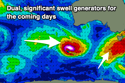
As touched on in Wednesday's update, a temporary low point in swell is due early Sunday but it won't last long, with the next pulse of strong groundswell due to arrive shortly after dawn, filling in strongly through the afternoon then easing Monday.
The source of this swell is a 'bombing' low which has formed thanks to the remnants of a tropical cyclone in the Indian Ocean (Anggrek), drifting south-east and being absorbed into the westerly storm track. A strong upper level jet will help feed this low, with a great fetch of severe-gale to storm-force W/NW tending W winds due to be generated through our south-western and then southern swell windows.
This should produce another large pulse of SW tending S/SW groundswell, building back to 4-5ft+ across Middleton into the afternoon, tiny and 1ft to possibly 1-1.5ft in the gulf.
Conditions look favourable in the morning as the swell builds with local offshore winds again from the N/NE down South, E/NE on the Mid, with weak sea breezes in the gulf and a shallow S/SW change down South early afternoon, stronger into the evening.
Make the most of the surf before this change hits, as next week looks poor with a persistent onshore S-S/SE flow due from Monday through Wednesday, improving a little on Thursday but with no decent swell. So all in all the weekend is the go for a surf. Have a great weekend!
Comments
Having spent a fair bit of time on the Sunny Hoax, it's hard to get my head around the idea that good swell and good winds can just happen whenever, there's nothing special about the synoptics. Can't wait.
965 hpa swell Satuday morning& 953 bombing Low Sunday morning not exactly common Sunny,even back in my day! Get amongst it :)
Waves have been good but missing the crowds, lowest since the early 2000s !
Why are most of the cams offline?
Middleton modem fried a few days ago. Unfortunately, 'overnight delivery' to Middleton seems to be five days.
Chiton Rocks (and Hayborough) is experiencing a regional power outage via SA Power Networks, it's due back at 3pm. Just bad timing.
I know it's been a long time since the Victor Harbor region has had a swell with Northerlies but giving the surf report Sat morning 9/10 is drawing a very long bow. I surfed this morning and I'd give it a 6/10 if ya lucky. Let's keep a lid on the 8's and 9's and keep them for when it's actually real good!
Very very underwhelming swell on the YP. Not very significant at all even at the spots that like south swell
Yeah blocked by KI.
Hey? SSW swell blocked by KI at spots that like south swell on the yorke peninsula? Ok then, u live and learn.
Yeah this wasn't a classic SSW swell if you looked at where the source was. More so south with the fetch off Tassie.
Ok, cheers Craig.
Spots that like west in the swell were also very small, very underwhelming
Saw some photos from the south coast this morning. Big down there.