Lots of swell inbound with improving winds for the South Coast

South Australian Surf Forecast by Craig Brokensha (issued Wednesday January 31st)
Best Days: Today Mid Coast, tomorrow morning both coasts, Saturday South Coast, early Sunday South Coast
Features of the Forecast (tl;dr)
- Moderate sized W/SW-SW swell building Wed PM, easing Thu AM
- Strengthening S-S/SE winds this afternoon, light-mod S/SE-SE tomorrow AM (S/SW-S down South), strengthening into the PM
- Smaller Fri AM with moderate S/SE winds in the AM, freshening
- Late increase in mid-period S/SW swell Fri
- Large S/SW groundswell Sat Am, easing with N/NE winds ahead of weak sea breezes
- Secondary strong SW groundswell Sun with early N/NE winds ahead of a strengthening SW change mid-late AM
Recap
The South Coast has offered bumpy but surfable waves the last two mornings with a moderate onshore wind and 2-3ft of swell across Middleton.
The Mid Coast has seen reinforcing levels of W/SW swell maintaining tiny waves mostly to 1ft to occasionally 1.5ft yesterday, while a stronger pulse of swell today is more to the consistent 1.5-2ft range.
We should see this swell muscle up further to a more consistent 2ft this afternoon on the sets as winds remain workable.

New W/SW swell today
This week and next week (Jan 30 – Feb 4)
We've got a very active and dynamic period of surf ahead thanks to strengthening storms once south of the country, feeding off a strong upper level jet (strong jet stream) to the south of Western Australia.

Strong upper jet sitting south-west of Western Australia
Essentially, any storms moving through this region are being strengthened, producing a ton of swell for the forecast period though with slightly tricky winds, as we're slightly downwind of the activity (which is focussed towards Tasmania).
Coming back to today though and our good pulse of mid-period W/SW swell for this afternoon should provide 2ft waves on the Mid Coast and boost the South Coast to 4ft on the sets across Middleton, easing back from a similar size tomorrow morning across both regions.
Winds are due to strengthen from the S tending S/SE into this afternoon/evening, keeping the Mid Coast relatively clean.
Tomorrow, S/SE-SE winds will favour the Mid Coast again, with a light to moderate onshore S-S/SW flow due down South offering OK conditions for the keen.
Into Friday, lingering light to moderate S/SE winds are due on the South Coast with a bit less swell, tiny on the Mid Coast.
Into the afternoon, building surf is due, peaking Saturday large out of the S/SW, linked to one of the strengthening storms under the influence of the strong jet.
This will develop to the south of the Bight today, with a strengthening fetch of W'ly gales due to then be projected north-east, across Tasmania tomorrow and Friday, through our southern swell window.
Friday afternoon's increase in energy looks mid-period in nature, with the groundswell arriving overnight, peaking Saturday morning. 5-6ft sets are likely across Middleton through the morning with tiny 1ft waves on the Mid Coast, easing through the day.
Conditions looks great Saturday morning for the South Coast as winds shift light N/NE and sea breezes only look weak, providing a full day of quality surf.
There'll be little to no downtime between swells heading into Sunday, with the next strong pulse of SW groundswell due to arrive around dawn.
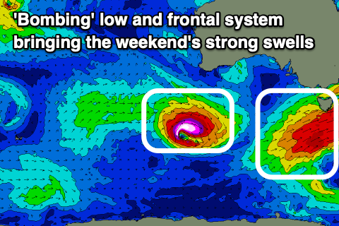
This will be generated by a 'bombing low' with the catalyst for it being the remnants of Tropical Cyclone Anggrek in the Indian Ocean being absorbed into the westerly storm track, and then deepening significantly with the help of the upper jet.
The low will be quite tight but generate storm-force W'ly winds while tracking east-southeast through our south-western swell window.
The fast track and tight nature may limit the size a little but we're looking at another kick to 4-6ft across Middleton during the day with the Mid Coast coming in at a tiny 1ft to possibly 1.5ft on the favourable parts of the tide.
Winds look favourable early again, but a trough will bring a SW change mid-late morning so surf before then. The South Coast should see a N/NE offshore, NE on the Mid, with strengthening S/SW winds into the afternoon.
As touched on in Monday's update, following this change, persistent S/SE winds are due into next week with no major swell sources so make the most of the coming days.