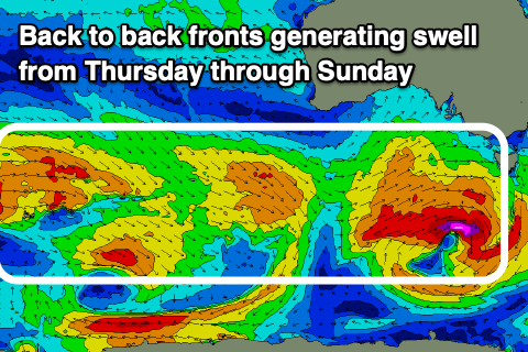
Good period of surf for both regions
South Australian Surf Forecast by Craig Brokensha (issued Monday April 17th)
Best Days: Today South Coast, tomorrow morning South Coast, Wednesday Mid Coast, Thursday and Friday both coasts, Saturday South Coast, Sunday South Coast, Monday morning South Coast
Features of the Forecast (tl;dr)
- Easing swell down South tomorrow with N/NW tending W winds ahead of a late SW change (N/NE early on the Mid)
- Small W/SW swell on the Mid tomorrow
- Moderate sized W/SW swell building Wed, peaking in the PM, easing a touch Thu on the Mid, holding down South
- Fresh but easing S/SW tending S winds down South Wed, S/SE-S early and late on the Mid, S/SW otherwise
- Early S/SE winds on the Mid Thu, tending SW (W/NW early down South)
- Reinforcing W/SW-SW swell for Thu PM, easing Fri
- Light E tending NW winds on the Mid Fri, variable tending SE down South
- Easing surf Sat with local offshore winds ahead of sea breezes
- Moderate sized W/SW groundswell building Sun, peaking in the PM, easing Mon
- Local offshore winds ahead of sea breezes Sun, NW tending SW Mon
Recap
Clean conditions in protected spots down South on Saturday with a smaller 2ft of swell, poor and choppy on the Mid Coast. Yesterday was average across both coasts with SW winds and a small start to the day down South, bumpy and to 1-2ft on the Mid Coast.
This morning conditions are great down South along with 3ft waves off Middleton and options all over. The Mid Coast is bumpy and wind affected but holding 1-2ft on the sets for the desperate.

This week and weekend (Apr 18 - 23)
Tomorrow will be the smallest of the period, with today's mix of mid-period W/SW swell and background S/SW energy due to ease to 2ft across Middleton while the Mid Coast should hold 2ft on the favourable parts of the tide thanks to a small, reinforcing swell.
Winds will favour the South Coast again tomorrow, N/NW through the morning, shifting W'ly into the afternoon ahead of a late SW change. The Mid will be bumpy with early N/NE winds, shifting N/NW and then W later.

The change in winds will be linked to a healthy mid-latitude frontal system that's currently south-western of Western Australia, pushing east towards us, bringing a moderate sized pulse of W/SW swell for Wednesday afternoon.
This progression started over the weekend and we're seeing strong to gale-force W/SW winds projected east, with the Mid Coast due to build from 2ft in the morning to 3ft with the incoming tide, holding 2ft to possibly 3ft on the favourable parts of the tide Thursday as the more distant swell from the earlier stages of the storm fills in.
The South Coast should build through Wednesday and reach 4ft, holding this size Thursday.
The easing trend on Friday will be slowed thanks to a strengthening frontal system pushing in on the back of Wednesday's swell generator, and this should maintain 3-4ft sets off Middleton, with 2ft sets across the Mid Coast, easing from 2-3ft and 1-1.5ft respectively on Saturday.
Looking at the local winds and following later tomorrow's change, winds should tend S/SE-S across the Mid Coast early Wednesday, shifting S/SW through the morning and back to the S/SE later. The South Coast will be bumpy all day with fresh but easing S/SW winds.
Thursday looks decent for both coasts with a light S/SE wind on the Mid Coast, W/NW down South before shifting SW through the day.
Friday looks cleanest on the Mid Coast with a light E/SE offshore ahead of weak sea breezes, while the South Coast may be a touch dicey with lingering light, S winds, but most likely variable and light W/NW. We'll confirm this Wednesday.

Into the weekend, Saturday looks clean across both coasts in the morning with local offshore winds, best down South with the tiny swell on the Mid Coast.
A new, moderate sized W/SW groundswell is due to build through Sunday, produced by a tight and intense but small low firing up to the south-west of Western Australia. A quick fire fetch of severe-gale W/SW winds will generate a long-period swell that will hopefully push to 1-2ft on the Mid Coast through the day and 3-4ft off Middleton into the afternoon.
Light, local offshore winds are again expected ahead of moderate to fresh sea breezes.
Into next week, there's plenty more swell due thanks to continued frontal activity pushing in from the west. Winds will strengthen from the NW tending SW on Monday/Tuesday before easing and improving mid-late week, but we'll look at this in more detail on Wednesday.


Comments
Goodbye La Nina. You will not be missed.
The dead fish are clearing too. Things are looking up
Post Easter we've had 3 all day offshore days. Today is the pick, warm, sunny, clean and 2-4'
Can't express how good this is, it's been a very long wait.
Amen people...Amen!
Yes lads!