Get in ahead of the change today

South Australian Surf Forecast by Craig Brokensha (issued Friday September 23rd)
Best Days: This morning, Mid Coast tomorrow, South Coast Sunday morning, Mid Coast Tuesday morning and later week
Features of the Forecast (tl;dr)
- Moderate sized W/SW groundswell for this afternoon, easing slowly on the weekend with a strengthening S/SW-S change late AM down South, early PM on the Mid
- Easing surf tomorrow with E-E/SE tending S/SE winds
- Smaller Sun with N/NE tending E/NE winds
- Building W/SW groundswell Mon PM with mod S/SW winds, strengthening through the day
- Reinforcing W/SW swell Tue with S/SE tending S/SW winds
- Moderate sized W/SW groundswell for Thu/Fri with S-S/SE winds
Recap
Great conditions across both regions yesterday with our first pulse of W/SW swell coming in at 2ft across the Mid Coast and 3-4ft across Middleton under light offshore winds and weak sea breezes.
This morning we’ve got great conditions again but they won’t last, with a trough due to bring a strong S/SW-S change later morning down South and early afternoon on the Mid, so get out there before it hits.

Great waves yesterday AM
This weekend and next week (Sep 24 - 31)
Looking at the coming weekend and we’ve got our strongest pulse of W/SW groundswell due to arrive this afternoon, peaking overnight and easing slowly through the weekend.
The trough will clear to the east fairly quickly overnight allowing winds to swing offshore from the E/SE tomorrow morning across the Mid Coast, E/SE-E for the South Coast.
Size wise we should be seeing 3-5ft waves across the Middleton stretch but with those less than ideal winds and conditions with super fun 2ft+ sets on the Mid Coast, easing through the day.
Sunday looks great for South Coast with N/NE winds during the morning but they’ll shift E/NE through the day, so get out for the early. Easing sets from 3ft are due across Middleton and 1-1.5ft on the Mid Coast, also with great conditions.
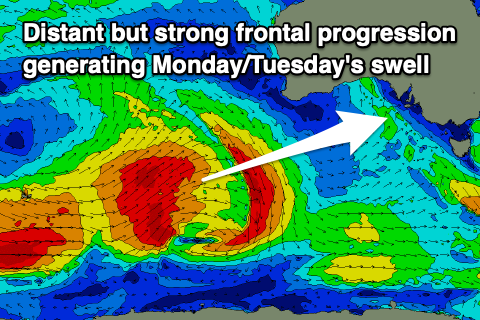 Monday morning looks smaller again ahead of our new, strong W/SW groundswell into the afternoon. This was generated through yesterday, with a fetch of gale to just under severe-gale W/SW winds produced south-west of Western Australia into the evening and it’s now weakening while pushing north-east, on approach to the mainland.
Good 3-4ft sets are due across Middleton into the afternoon with 2ft sets on the Mid Coast mid-late afternoon, with similar sized waves on Tuesday morning.
Winds are a little tricky due to another trough moving in from the east, bringing moderate S/SW winds, strengthening through the day, creating average conditions.
Tuesday is similarly tricky with S/SE winds at dawn, shifting S/SW and strengthening through the day as the trough deepens into a low off the East Coast. With this, the Mid will be best as the South Coast becomes choppy.
The low is forecast to strengthen bringing persistent S/SW strong winds into Wednesday, weakening into Thursday but remaining from the S’th.
This will spoil another good pulse of W/SW groundswell Thursday/Friday on the South Coast, with slow 1-2ft sets on the Mid Coast. More on this Monday. Have a great weekend!