Strong swell on the build

South Australian Surf Forecast by Craig Brokensha (issued Monday August 29th)
Best Days: Today South Coast, Wednesday South Coast, South Coast Thursday morning, Mid Coast for the keen Friday morning, South Coast Sunday morning, South Coast Monday and Tuesday mornings next week
Features of the Forecast (tl;dr)
- Moderate-large sized, long-period W/SW groundswell for Mon PM with freshening NW winds
- Easing swell tomorrow with strong SW winds, easing gradually during the day
- Low point in swell Wed AM with N/NW tending NW winds down South, NE tending N/NE and N/NW on the Mid
- Reinforcing mid-period SW swell Wed PM and Thu AM with a stronger SW swell Fri
- NW winds Thu AM, shifting SW early PM, with mod-fresh S'ly winds Fri (S/SE early on the Mid)
- Easing SW swell Sat and Sun with moderate S tending S/SE winds Sat, E/NE Sun AM
- Fun S'ly swell for Mon with N/NE-NE winds, easing Tue with similar winds
Recap
Fun surf all weekend down South with a drop in size from Friday on Saturday along with improving conditions with a persistent N/NE breeze. Yesterday was clean as a whistle but smaller and best on the swell magnets.
The Mid Coast dropped right back in size on Saturday with clean tiny leftovers for beginners, bumpy and near flat yesterday.
This morning we've got an inconsistent, long-period W/SW groundswell on the build with it now kicking up in size on the Cape du Couedic buoy.
We should see the Mid Coast reaching 2-3ft by later today but with fresh NW breezes, clean down South and with sets due to reach 4-6ft by dark across Middleton.
This week and weekend (Aug 30- Sep 4)
Looking at the outlook for tomorrow, and our moderate-large W/SW groundswell due into this afternoon and evening will start to ease through tomorrow but the main change is the local winds.
 A trough that was expected to bring a late a change today has stalled a little and formed into a low pressure system. This will see the change delayed until early tomorrow morning, killing off the chance for early favourable winds on the Mid Coast.
Strong SW winds are due at dawn tomorrow, easing gradually through the day as the low moves further east but conditions will be poor to average with easing 2ft to occasionally 3ft sets on the Mid and 4-5ft waves across Middleton.
Wednesday will be smaller but cleaner across all locations with a light to moderate NE tending N/NE breeze on the Mid, N/NW into the afternoon. The South Coast should see N/NW tending NW winds.
 Size wise Middleton looks to be back to 2-3ft with 1ft to possibly 2ft sets on the Mid Coast but with the early morning high tide (not ideak). Into the afternoon a new pulse of mid-period SW swell is expected, peaking Thursday morning ahead of a secondary, better pulse on Friday.
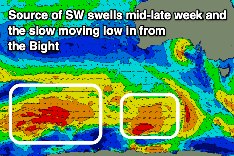
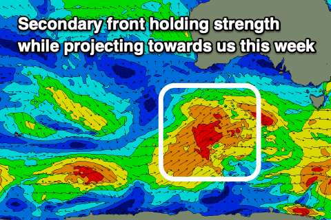
These swells have been and will continue to be generated persistent polar frontal activity around the Heard Island region and further to the east. Fetches of strong to sometimes gale-force W-W/SW winds are being generated, with an initial front generating later Wednesday and Thursday's swell while a secondary, front will hold its strength while projecting up towards us over the coming days.
Later Wednesday and Thursday morning's first pulse should come in at 3ft+ across Middleton with tiny 0.5-1ft waves on the Mid Coast. Conditions look great Thursday morning with a NW offshore, shifting SW early afternoon with a trough moving in from the west.
 Friday's swell will be stronger and to 4-5ft across Middleton with 1-1.5ft sets likely on the Mid Coast magnets but with moderate to fresh S'ly winds (tending S/SE early on the Mid and S/SW down South). This southerly breeze will be thanks to a high ridging in behind the trough, though it will stall and be blocked from moving further east thanks to a strong polar outbreak to the south-east of Tasmania.
This will leave lingering onshore S/SW winds Saturday, tending S/SE through the day with better E/NE-NE winds on the cards for Sunday. This will be with easing surf, dropping from the 4ft range Saturday and 3ft Sunday.
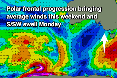
Early next week looks cleaner and better for a surf with N/NE winds and a good pulse of S/SW swell from the polar frontal progression developing under Tasmania. More on this Wednesday.
Comments
It's inconsistent, but the swell is starting to show..