Improving South Coast surf from Friday, great weekend

South Australian Surf Forecast by Craig Brokensha (issued Wednesday August 24th)
Best Days: Mid Coast tomorrow morning for the keen, South Coast Friday morning but more so Saturday and Sunday, South Coast Monday ahead of the PM change, Mid Coast Tuesday, South Coast Wednesday
Features of the Forecast (tl;dr)
- Moderate sized, reinforcing SW swell Thu and Fri with S/SE tending S/SW winds on the Mid Thu, S/SW down South
- Light NE tending E/SE winds on Fri
- Easing SW swell Sat with N/NE tending variable winds, smaller Sun with mod-fresh N/NE tending N/NW winds
- Moderate-large sized, long-period W/SW groundswell for Mon PM with freshening W/NW winds ahead of a late strong W/SW change
- Easing swell Tue with moderate S/SW winds
Recap
Poor surf across both coasts yesterday with strong onshore winds and a mix of new SW swell energy, solid down South and only really surfable in protected spots for the keen.
Today conditions are a bit cleaner and more organised with some reinforcing SW swell energy, best in protected spots on the South Coast.
This week and weekend (Aug 25 - 28)
We've got plenty of swell due to continue across the South Coast over the coming days with improving conditions from Friday.
The last two days's swells were generated by an initial polar low and follow up frontal system, with a slight drop in size expected tomorrow ahead of some mid-period SW swell which will steady wave heights through the day and Friday.
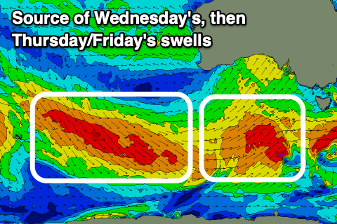 This reinforcing energy has been generated by a broad and elongated fetch of strong to near-gale-force W/NW tending W winds swinging in under the country, with a final, trailing front today due to generate one final pulse of reinforcing energy Friday afternoon and Saturday morning.
Size wise, Middleton should come in around 3-4ft tomorrow with the Mid Coast easing back from 1-2ft, while Friday should see 3-4ft sets continuing across Middleton, tiny on the Mid and to 1ft+.
Winds will favour the Mid Coast tomorrow with an early S/SE breeze likely, tending S/SW through the day. The South Coast will be bumpy but workable for the keen though better Friday with a light NE offshore, E/SE into the afternoon.
The weekend looks the pick for the South Coast with a N/NE tending variable wind and easing mid-period SW swell from 3ft+, tiny on the Mid Coast and to 0.5-1ft. Sunday should be 2ft to occasionally 3ft at dawn but slowing, easing through the day with fresh N/NE tending N/NW winds.
Moving into next week and we'll see a temporary low point in swell at dawn Monday ahead of the arrival of a moderate-large sized, long-period W/SW groundswell which is due to peak late afternoon.
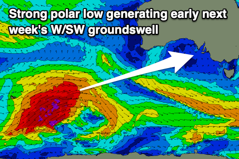 An initial polar low has formed south-east of South Africa, but we'll only start to see a favourable swell generating fetch from this system once it nears Heard Island tomorrow. Once it does, a great fetch of severe-gale to storm-force W/SW winds are forecast to be generated, projecting north-east towards Western Australia and more into our western swell window.
This should generate a strong W/SW groundswell which will build through Monday and reach 4-6ft across Middleton into the afternoon with 2ft to possibly 3ft sets on dark across the Mid Coast. Winds will deteriorate for the Mid and freshen from the W/NW, giving into a strong W/SW change late afternoon as the remnants of the storm moves across us, average Tuesday with S/SW winds lingering across all locations along with easing sets.
Cleaner conditions and fun pulses of reinforcing SW energy are due mid-late next week but we'll look at this in more detail on Friday.
Comments
the southern ocean finally firing up right at the end of winter