Cold, onshore week

South Australian Surf Forecast by Craig Brokensha (issued Monday June 6th)
Best Days: Keen surfers protected spots South Coast Friday and Saturday mornings, next Monday and Tuesday mornings down South
Features of the Forecast (tl;dr)
- Mix of S'ly swells tomorrow, easing temporarily into Wed and Thu
- Strong SW winds tomorrow, shifting S/SW into the PM with S/SW-SW winds on Wed
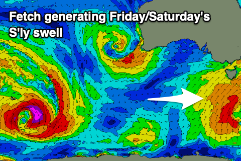
- New, moderate sized, mid-period S'ly swell Fri/Sat
- Gusty SW winds Fri through Sat (likely W'ly early each morning around Victor)
- Mod-large S'ly swell building Sun, easing Mon with S/SW tending S/SE winds Sun, N/NE tending E/SE Mon
Recap
Good waves across the South Coast all weekend, best in semi-protected spots and to 2-3ft across Middleton Saturday, similar in size Sunday. The Mid Coast saw building windswelly waves on Saturday, stormier and to 3ft yesterday.
Today conditions are still poor on the Mid but a little more organised, bigger down South and to 3-4ft with cross-offshore winds which has just started to swing more onshore.
This week and weekend (Jun 7 – 12)
Cold, windy and with persistent showers.
Following last week's cold outbreak we're now under the influence of a second but more prolonged cold episode as a strong node of the Long Wave Trough pushes slowly across the south-east of the country and towards the Tasman Sea.
This will project a flurry of cold, polar fronts up and into Tasmania, strengthening as the week progresses, but in all respects strongest once behind the swell shadow of Tasmania.
This will result in moderate pulse of mid-period S'ly swell for the South Coast over the coming week and weekend but with persistent onshore winds out of the south-western quadrant.
 Quality wise it's not great and locally winds will be poor with strong SW breezes due tomorrow, S/SW into the afternoon and then fresh S/SW-SW on Wednesday. Size wise a mix of swells to 3ft+ is due across Middleton tomorrow, back to 3ft on Wednesday and Thursday.
Some new S'ly swell is due Friday with sets to 3-4ft due across Middleton but winds will remain onshore from the SW on Thursday and Friday (likely tipping lighter W'ly each morning for a period around Victor).
Saturday should see similar gusty SW winds persisting across the South Coast (likely W'ly early) with Sunday finally seeing winds start to swing back anti-clockwise as a high moves in from the west. This will bring S/SW tending S/SE breezes before shifting back to the N/NE on Monday.
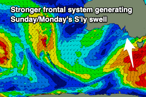 Swell wise the strongest fronts projecting up and into Tasmania should generate some better S'ly swell Sunday to 4-5ft across Middleton, easing from a similar size on Monday with those better winds.
Through this whole period the Mid Coast won't see any size at all with tiny windswelly waves set to prevail.
We'll see easing swells from the S and favourable winds through the middle to end of next week, with the next increase in size likely to arrive from the W/SW. More on this Wednesday.