Poor outlook continues

South Australian Surf Forecast by Craig Brokensha (issued Friday January 21st)
Best Days: No good days
Features of the Forecast (tl;dr)
- Tiny, inconsistent W/SW swell Sat PM and Sun with strengthening E/NE winds
- Secondary, tiny inconsistent W/SW swell for Tue PM, easing Wed with variable tending SW winds
Recap
Fun waves across the South Coast yesterday morning with a peaky S/SE windswell to 2ft or so with offshore winds, strengthening from the E/NE into the afternoon ahead of late sea breezes. Today conditions are clean again but the surf is tiny. The Mid Coast has been tiny to flat the last couple of days.
This weekend and next week(Jan 22 - 28)
After a couple mornings of clean small surf, we're now heading into a period of very minimal swell though favourable winds.
The reason for the lack of swell and favourable winds is due to a strong high sitting over Tasmania, with weak mid-latitude fronts pushing in from the Indian Ocean dipping south-east while breaking down. A secondary high will then slide in from the west and join the main high, setting up a more elongated, broader blocking pattern.
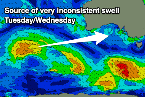 Some tiny, inconsistent, mid-period W/SW swell is due off the weak mid-latitude fronts pushing in from the southern Indian Ocean, the first arriving tomorrow afternoon and peaking Sunday to 1ft on the Mid Coast, with a secondary pulse for Tuesday afternoon and Wednesday to a similar size. The swells will be tiny on the South Coast as well and only coming in at 1-1.5ft max across Middleton-Goolwa.
We'll see favourable winds as a broad area of low pressure sits to our west, stalling across the Bight through the weekend and early next week before sliding east Tuesday and Wednesday.
This trough will squeeze the high across Tasmania, directing persistent NE winds across us, creating clean conditions each morning, tending variable tomorrow afternoon with strengthening E/NE winds on Sunday.
Monday should see persistent, fresh NE winds, shifting lighter E/NE into the afternoon and then variable tending light SW on Tuesday as the trough/low drifts across us.s. With the trough/low continuing across us Wednesday winds look variable in the morning again ahead of afternoon sea breezes, with fresher W'ly winds on Thursday. There'll be no swell generated by this change with it being relatively weak and having no length behind it.
Another high looks to fill in next weekend swinging winds around to the S/SE but with no major swell sources. So get those dings fixed and do the chores around the house ahead of the next proper swell. Have a great weekend!
Comments
Sigh...
glad i didn't rent an air b and b down south for 2 weeks
Looks like the perfect time to be in iso! Haha!
Still pumping at Cactus everytime. yout should find the secret spot
Just making salltwaves
Mostly Ben Swellnet has the models setup for you and freeride to make it a story
Nice!