Great run for the South Coast, with semi-windows for the Mid Coast

South Australian Surf Forecast by Craig Brokensha (issued Wednesday July 28th)
Best Days: Protected spots down South late today, Mid Coast for the keen tomorrow morning and into the evening, along with Friday morning, South Coast all period
Features of the Forecast (tl;dr)
- Large W/SW groundswell easing tomorrow with fresh to strong N/NW winds down South (fresh N/NE for a period in the morning on the Mid and into the evening)
- Easing W/SW groundswell Fri with similar winds to Thu
- Building mid-period W'ly swell Sat PM with moderate-fresh N/NW winds down South (N/NE early on the Mid)
- Moderate-large, inconsistent W/SW groundswell peaking Sun with moderate NW winds, easing Mon with stregthening N/NW tending NW winds
- New W/SW swell Tue but with fresh SW winds
Recap
Northerly winds created choppy conditions on the Mid yesterday with the swell hanging in around the 2ft+ range, while the South Coast dropped back to 2-3ft across Day St and Goolwa, with windy, though fun waves in selected spots.
Today we've got strengthening W/NW winds as a vigorous mid-latitude front pushes across us, bringing a stormy increase in swell on the Mid that'll get to 3-4ft, while some new swell is showing on the South Coast with 3ft sets across Middleton, increasing a bit more later.
This week and weekend (Jul 29 – Aug 1)
The second vigorous mid-latitude front in a handful of days is now pushing in and across the state, whipping up stormy waves on the Mid, while we should see building surf down South into the afternoon as well.
3-4ft surf is due on the Mid but with strong W/SW winds, while Middleton should build to 4-5ft by dark as winds hold from the W. Try protected spots.
 We'll see today's building, mid-period energy easing tomorrow, mixed in with stronger levels of W/SW groundswell (from the earlier stages of the frontal progression) and this should maintain 3-4ft sets on the Mid through the morning, smaller into the afternoon.
The South Coast will be solid and to 4-6ft across the Middleton to Goolwa stretch along with fresh to strong N/NW winds, creating great conditions. The Mid Coast will be bumpy and choppy but workable with winds tending fresh N/NE for a period through the morning, then back to the N/NW thereafter, back to the N/NE on dark.
Friday will see the swell becoming smaller, easing from 3ft to possibly 4ft down South, 2ft to occasionally 3ft on the Mid Coast but with similar winds to tomorrow. Fresh to strong N/NW down South and similar on the Mid, apart from a period of early N/NE winds.
Lighter winds are due Saturday morning, moderate to fresh N/NW down South, and similar on the Mid (though N/NE early again) along with an early low point in swell. Middleton looks to be 2ft to possibly 3ft, with the Mid back to 2ft on the sets.
This will only be temporary with some new mid-period W'ly swell due to arrive mid-late morning, ahead of an inconsistent W/SW groundswell on Sunday.
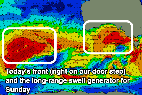
Firstly, looking at the long-range groundswell, and this is being generated by a significant polar low firing up around the Heard Island region, generating fetches of severe-gale W/SW winds. This low will project these winds up and towards Western Australia through our western swell window, weakening once passing under their state Friday and Saturday.
This swell is best aimed for the Mid Coast, with it due to fill in Sunday, but the frontal activity under WA will generate an increase in mid-period W'ly swell ahead of it Saturday afternoon.
Size wise the Mid should build Saturday to 2-3ft through the afternoon, with the South Coast increasing towards a more consistent 3ft under those N/NW winds outlined above.
Sunday looks best down South with NW offshores and a peak in groundswell to 3-4ft+ across Middleton, while the Mid will be bumpy but a strong 3ft.
Into next week, winds will strengthen from the N/NW on Monday as Sunday's swell slowly eases, giving into an evening change, SW into Tuesday.
Longer term another, moderate sized W/SW groundswell is due Tuesday with this SW change, but we'll take a closer look at this on Friday.