Lighter winds and fun swell pulses

South Australian Surf Forecast by Craig Brokensha (issued Wednesday May 26th)
Best Days: Both coasts tomorrow morning, South Coast for the keen Friday morning, Saturday morning South Coast, Sunday and Monday both coasts
Features of the Forecast (tl;dr)
- Easing W/SW swell tomorrow with local morning offshore winds and weak sea breezes
- Mid-period S/SW swell Fri, easing Sat with variable S/SW winds on the South Coast, SE on the Mid in the AM, easing Sat with morning NE winds
- New moderate sized W/SW groundswell filling in Sun with NE tending variable winds, easing Mon with similar winds
Recap
An inconsistent though new pulse of swell for yesterday down South, windy but clean in Middleton all day though only for the patient with sets to 3ft in the morning, a little slower through the afternoon.
The Mid Coast build through the day to a stormy 3ft+ or so for the keen, easing back in size today from 3ft with easing onshore winds. The South Coast was windy with a close-range swell to 3ft+, best in protected spots.
This week and weekend (May 27 - 30)
Today's windy swell is close-range energy generated by a fetch of W/SW gales on the backside of the mid-latitude low that pushed through yesterday.
We'll see this energy easing through tomorrow as the low pushes across Victoria today, while a trailing fetch of SW winds in the wake of the low now looking a little less favourable for swell production.
We should still see a reinforcing, mid-period S/SW swell for Friday but under the size due Monday.
Size wise, Middleton should ease back from 3ft tomorrow morning, with the mid-period swell maintaining 3ft sets on Friday, easing from 2-3ft Saturday.
The Mid Coast should still be around 2ft tomorrow morning, back to 1-1.5ft on Friday and tiny Saturday.
Winds look to be favourable for both coasts tomorrow morning with hi-res modelling showing a light W/NW breeze around Victor Harbor, though with a bit of leftover lump, variable E/SE on the Mid Coast ahead of weak sea breezes.
Friday should see a SE breeze on the Mid Coast but the South Coast looks a touch dicey with a light to moderate S/SE breeze, possibly variable through the morning.
Moving into the weekend, winds should swing around to the NE across the South Coast with the easing S/SW swell, moderate to fresh N/NE tending E/NE Sunday along with the arrival of a new, infrequent W/SW groundswell.
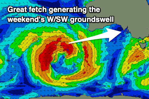 The source of this swell will be a strong mid-latitude low moving through the Indian Ocean, but fairly north in latitude, in our western swell window.
A persistent fetch of W'ly gales will be produced, with the low breaking down, south-west of Western Australia on Friday morning.
The swell should push east and arrive Saturday evening, filling in Sunday and reaching 2ft on the Mid Coast with 3ft sets likely on the magnets with the favourable parts of the tide.
Middleton should build to 3ft+ with 4ft sets towards Goolwa owing to the westerly swell angle.
Winds as outlined above look favourable, though shifting N/NW ahead of going variable Sunday afternoon on the Mid, similar Monday as the swell eases in size.
Longer term there's nothing too significant on the cards with another mid-latitude low due to form off Western Australia but it won't be favourable for swell production, with limited Southern Ocean activity.
We may see an increase in frontal activity late next week, but more on this in the coming updates.
Comments
Great forecasting graig, will next Monday's swell still have the westerly component in it?