Fun swell to end off the week

South Australian Surf Forecast by Craig Brokensha (issued Wednesday March 24th)
Best Days: Possibly late tomorrow on the Mid, most of Friday on the Mid, South Coast until mid-afternoon Friday, desperate surfers Saturday morning in protected spots down South
Features of the Forecast (tl;dr)
- Fun, mid-period W/SW swell building Thu PM with easing SW winds late, easing Fri with light, local offshore winds early, deteriorating into the afternoon
- Nothing major until late next week
Recap
Our new W/SW groundswell filled in on forecast yesterday with clean 1-2ft waves on the Mid before sea breezes ruined it into the afternoon. The South Coast remained average with no size and bumpy conditions.
This morning both coasts are poor with a drop in swell and moderate to fresh onshore breeze.
This week and and next (Mar 25 – Apr 2)
Into the end of the week we've got a fun W/SW-SW swell due to fill in across the state, generated by a stalling and now eastward tracking mid-latitude low from under Western Australia.
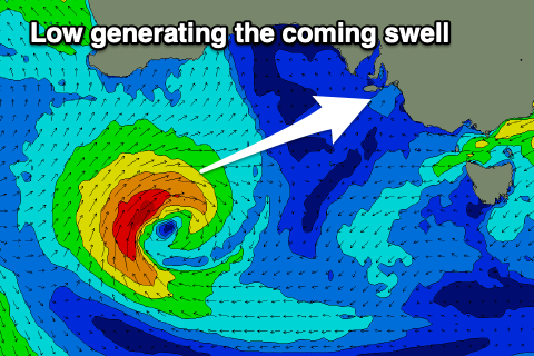 This low is now weakening while pushing towards Tasmania, south of the Bight and we should see the swell arriving later tomorrow, kicking to 2ft on the Mid Coast, then easing from 2ft on Friday.
Middleton should build to 2ft+ late tomorrow, with 2-3ft sets on Friday, easing into the afternoon and fading from 2ft Saturday.
Winds look to remain onshore most of tomorrow and moderate to fresh from the W/SW, easing off on dark on the Mid. The South Coast will see W'ly winds early but the surf will be tiny.
Friday looks clean across both coasts still, though the Mid Coast will become wind affected from late morning with a E/NE tending N/NE breeze, variable W/NW into the afternoon ahead of a late change.
The South Coast looks clean until mid-afternoon with winds more W into the late afternoon and evening.
The weekend isn't looking too flash with a weak front due to bring W/SW winds, W'ly early down South and a background 1-1.5ft or so of swell on the Mid Coast.
Sunday will be smaller again and winds look variable, light W/NW on the South Coast early and E/SE on the Mid but tiny.
As touched on the last couple of updates, there's still nothing significant on the cards for early-mid next week, and the strengthening frontal activity firing up south-west of Western Australia under the influence of the Long Wave Trough looks to stall in our far swell window resulting in no real decent swell of size.
When will the activity push further east? It could happen into the Easter Long Weekend, but more on this in the coming updates.