Try and surf this week, next week looks very slow

South Australian Surf Forecast by Craig Brokensha (issued Monday March 15th)
Best Days: Mid Coast tomorrow, and beginners Wednesday, keen surfers South Coast Wednesday morning but more so every morning from Thursday onwards through Sunday, Mid Coast Friday and Saturday
Features of the Forecast (tl;dr)
- Strong S/SW groundswell building tomorrow afternoon with SE tending S/SE winds, easing Wed with morning E/SE winds ahead of sea breezes
- Easing S/SW swell Thu with a light NE wind ahead of sea breezes
- New, inconsistent W/SW swell for Fri, easing a touch Sat with light, locally offshore morning winds
- Nothing much at all for next week
Recap
A tiny start to the Mid Coast on Saturday, building into the afternoon with stronger onshore winds, cleaner and peaky to 1-2ft on Sunday morning, 1ft today. The South Coast was small and bumpy Saturday morning, with a bit more size Sunday but average winds.
Today the South Coast is much cleaner with a NW offshore and fun 2-3ft of swell across Middleton, but an onshore change has since moved through.
This week and next (Mar 16 - 26)
Looking at the coming forecast period, tomorrow's S/SW groundswell will be the most significant for the at least the next week and a half, if not two. Winds are still looking dicey though and far from ideal (for the South Coast).
The source of this long-period groundswell is a strengthening polar low on the weekend, with a fetch of W/SW gales from an initial front, reaching severe-gale as the low formed and deepened south-west of Tasmania in our southern swell window.
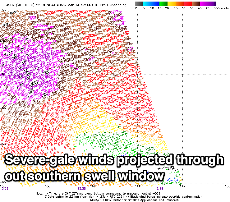
The whole evolution of the low was just a bit too far east of our swell window to generate any large surf, but we'll see a strong increase in S/SW groundswell tomorrow afternoon, easing through Wednesday.
Middleton looks to build from 3ft during the morning to 4-5ft into the afternoon, with the Mid Coast likely seeing mid-period energy from the earlier stages of the front to 1ft to occasionally 2ft on the magnets and favourable parts of the tide.
Winds will be moderate out of the SE, strengthening from the S/SE into the afternoon, favouring the Mid over the South Coast, with lighter E/SE-E winds Wednesday morning as the swell eases back from 3-4ft across Middleton. The Mid will be clean again but tiny and fading from 1-1.5ft.
Thursday looks better down South as winds tend variable NE along with easing, smaller surf from 2ft+ across Middleton.
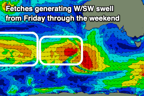 Into Friday a new mid-period W/SW swell is due, generated by a mid-latitude front that's currently projecting up towards Western Australian. A good fetch of strong W/SW winds will be projected through the Mid Coast's swell window, with the front then dipping south-east and turning into a strong polar low, but generally aimed out of our swell window.
The W/SW swell should arrive late Thursday but peak Friday with inconsistent sets to 1-2ft on the Mid Coast, while the South Coast looks to remain small and to 2ft. Conditions should be favourable for both coasts with a light, morning E/NE-NE breeze down South, E/SE on the Mid ahead of sea breezes.
A secondary unfavourable fetch of W/NW winds moving in behind this mid-latitude front should produce a secondary, reinforcing W/SW swell for Saturday but only to 1-1.5ft max on the Mid coast, 1-2ft down South and with light morning offshore winds across both coasts ahead of sea breezes.
The South Coast magnets will be the pick under this setup both Saturday and Sunday mornings.
Following this the high moving in, bringing this week's general easterly flow will block our major swell windows and there's nothing significant on the cards for next week or the following weekend. Therefore make the most of the coming swells!