Generally average outlook

South Australian Surf Forecast by Craig Brokensha (issued Wednesday March 10th)
Best Days: Tomorrow morning South Coast, Friday South Coast (swell magnets in AM), Mid Coast for a grovel Sunday morning, South Coast Monday
Features of the Forecast (tl;dr)
- Easing S/SW tomorrow with variable morning winds, increasing from the S'th from late morning, bottoming out Fri AM with N tending light S winds
- New mid-period S/SW swell building Fri PM, peaking Sat AM with strengthening SW tending S/SW winds
- Mix of swells Mon with a W/NW breeze, stronger out of the S/SW Tue but with SE morning winds
Recap
Our fun little swell for the Mid Coast was just that yesterday with 1-1.5ft waves and relatively clean conditions all day, easing back in size to a tiny 0.5-1ft today.
The South Coast saw plenty of size but average conditions, improving slightly this morning for the keen while still coming in around 3-4ft. Conditions have continued to improve with winds tending E/NE so get into it.
This week and next (Mar 11 - 19)
Tomorrow morning we'll see winds go more variable across the South Coast as the swell from the past couple of days eases more noticeably, dropping from 2ft+ across Middleton and tiny to flat on the Mid. Keeping in mind variable could be anything from light offshore to light onshore and tomorrow morning looks to tend the latter into the mid-late morning, followed by increasing sea breezes.
 Friday looks cleaner with a light N'ly offshore but the swell will be at a low point and only 1ft to maybe 2ft across Middleton. Sea breezes look light so the afternoon should remain decent as a new, S/SW groundswell starts to build.
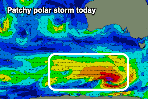
This swell (which now looks to be more towards the groundswell category compared to mid-period energy), is being generated by a patchy polar low that's currently south-west of Tasmania, with winds speeds mostly only strong, but reaching gale-force at its core.
It's not ideally angled for us but we should see a fun kick in size Friday afternoon, with the swell arriving a touch earlier owing to the slight increase in period, building to 2-3ft by dark across Middleton.
Saturday morning looks similar in size, easing through the day. An approaching front now looks to push in before dawn, bringing strengthening SW tending S/SW winds across all locations.
The front will be relatively weak and no major swell is expected in its wake, with Middleton holding a windswelly 3ft on Sunday, while the Mid Coast looks to build to 2ft Saturday, easing from 1-2ft Sunday. Conditions will remain poor down South with a fresh S/SW breeze, better on the Mid and S/SE early.
 A temporary drop in swell is expected Monday as winds relax, likely tending W/NW down South and variable on the Mid Coast through the morning.
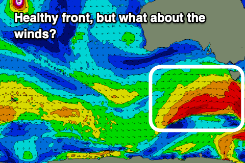
A fun, new S/SW groundswell is due Tuesday as a stronger, broader polar front fires up behind Saturday's front, generating a better fetch of strong to gale-force W/SW winds through our swell window.
The front will be fast moving but acting on an active sea state, with a good 3-4ft of S/SW groundswell likely Tuesday afternoon down South, tiny on the Mid Coast. Unfortunately a high moving in Monday evening will likely bring SE winds Tuesday, possibly better and E/NE Wednesday morning as the swell eases.
We'll have a closer look at this Friday though. Following this it looks like we'll see high pressure dominate our swell window as we push back towards positive Southern Annular Mode territory (pushing the storm track to the poles). This doesn't bode well for autumn fronts and swells, but more on this Friday.
Comments
Autumn really turning it on! Yew. Atleast it's consistent, consistently shit!
Lol its ok April is around the corner, bring on the WSW swells
Hey Craig do you have a synopsis of sa's autumn future endeavours. Love what we have had and the next few weeks outcome (not)
Hey Andy, always keeping a close eye on the longer term indicators, but at this stage nothing really stands out for the southern states unfortunately. March looks to be mostly a write-off.
Hopefully things change soon..
Typical summer SE for the 80th day straight. hopefully thanks to the COVID reset mother nature can get to normal delivering the goods.
Not sure if its just me but did we really just finish summer? Not many 40 oC from memory :(