Windy offshore, but worth making the most of

South Australian Surf Forecast by Craig Brokensha (issued Wednesday 3rd February)
Best Days: Thursday South Coast working the winds, Friday (protected spots into the afternoon)
Features of the Forecast (tl;dr)
- Easing SW swell tomorrow with N/NE tending NW and then back to N/NE winds (W/NW on dark again)
- Strong, inconsistent SW groundswell for Fri with strenthening N/NW tending NW winds, easing Sat as an onshore change moves through late morning
- New SW groundswell for Mon but with fresh S-S/SE winds, easing Tue/Wed as winds improve for the beaches
This week and next (Feb 3 - 12)
We’ve finally got offshore winds and a bit of swell due down South over the coming days. Firstly, today’s mix of swells will ease tomorrow and a cold front pushing up into the Bight will spawn into a mid-latitude low, stalling to our west, directing favourable winds across the South Coast.
Winds will swing from a moderate N/NE’ly to fresh NW’ly early tomorrow afternoon, back to the N/NE through the evening as a small trough pushes through. Middleton will be fun though on the small side and easing from 2ft to occasionally 3ft.
Our new, long-period and inconsistent SW groundswell is on track. The source of this swell was a strong polar low firing up south-west of Western Australia the last couple of days, with a great fetch of severe-gale to storm-force W’ly winds projected towards us.
 The low is now weakening and splitting, leading to that front pushing through the Bight, with the groundswell due to peak Friday with 3-4ft+ sets across Middleton, while the Mid Coast should offer 1-2ft sets from the frontal system before it spawns into the low. The low won’t be great for swell production but should still keep 1-2ft sets hitting the Mid into Saturday morning before easing.
Winds on Friday will be best in the morning, fresh from the N/NW but then strengthening out of the NW, shifting W/NW late in the day. This will also kick up some local windswell on the Mid.
The window for clean conditions Saturday morning down South looks slim with a strong morning W/NW breeze, shifting W/SW before lunch as the low pushes east, and the SW groundswell eases from 3ft+.
On the backside of the low we’ll see a small fetch of strong S’ly winds aimed in our swell window, but this will just keep some windswelly waves hitting the coast Sunday along with fresh S tending S/SE winds.
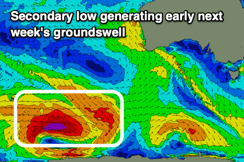 As touched on in Monday’s notes, this second pulse of long period SW groundswell looks similar to Friday’s, though likely a little less consistent and a touch smaller. The low linked to it is a touch more distant and smaller in scope but we’ll still see a generous fetch projected through our south-western swell window today and tomorrow. Weaker trailing fronts will also soften the easing trend after the swell peaks.
The swell is due later Sunday, peaking Monday with inconsistent 3ft to occasionally 4ft sets across Middleton, tiny on the Mid. Winds will unfortunately remain poor and onshore out of the E/SE tending S/SE Monday, better Tuesday from the E/NE in the morning and best Wednesday but the swell will be all but gone.
Longer term there’s nothing major on the cards, so try and make the most of the coming days favourable winds and surf.
Comments
Can't wait to take my 2 year old down to his first surf babies at South Port 8am on Saturday morning, just as the change hits... FFS! This summer keeps taking it's shitness to another level!