Workable waves all weekend

South Australian Surf Forecast by Craig Brokensha (issued Friday January 22nd)
Best Days: South Coast tomorrow, Sunday and early Monday, Mid Coast for the keen Tuesday
Features of the Forecast (tl;dr)
- New, inconsistent SW swell for tomorrow AM, with a S/SW groundswell for later and Sun with morning NE-N/NE winds
- Easing S'ly swell Mon with dawn N tending W/SW winds (freshening)
- Tiny W/SW swell for the Mid Tue with fresh SE tending stronger S/SE winds
Recap
Lighter morning winds and cleaner conditions across the South Coast yesterday and today, though the swell dropped away leaving the swell magnets with the best options. The Mid Coast has been effectively flat and unsurfable.
This weekend and next week (Jan 23 - 29)
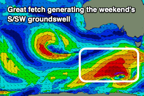
The coming few days are shaping up really nicely for the South Coast, with an upgrade in the S/SW groundswell due from a strong polar low that's currently drawn out to the south-west of Tasmania.
Before this arrives though, we should see a new, inconsistent SW groundswell arriving late today on the South Coast, peaking tomorrow morning.
 The first, least consistent swell was generated by a relatively weak polar low firing up south-southwest of WA earlier this week. We should see inconsistent 3ft sets across Middleton, tiny on the Mid Coast.
Into the late afternoon and more so evening, a stronger S/SW groundswell is due, with it currently being generated by an elongated polar fetch of W/SW gales drawn out to the south-west of Tassie. This fetch around a very slow moving and almost stalling polar low will remain just within our swell window today and early tomorrow morning before pushing east under Tassie.
An inconsistent but good increase in size is due from this source, kicking later tomorrow but peaking Sunday to 3-4ft across Middleton, easing from 3ft Monday morning.
Winds will improve over the coming days, light NE tomorrow morning ahead of S/SE sea breezes (not too strong) and then moderate to fresh N/NE-NE Sunday morning, tending variable ahead of a shallow SW change. Monday looks tricky with a dawn N'ly due to swing W/SW mid-morning, freshening from there as a trough moves in from the west, so aim for the early in protected spots.
This will spell the end of the favourable conditions for the South Coast with a high sliding in from the west, bringing S/SE winds through Tuesday, SE on Wednesday and possibly back to the NE Thursday but with no new decent swell.
Looking at the Mid Coast though and the mid-latitude low that's currently moving slowly through the southern Indian Ocean has been generating a small fetch of strong to gale-force winds through our swell window.
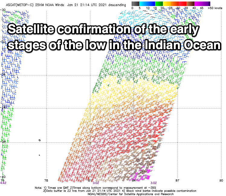 When the low was strongest but furthest away from us a good fetch of gales were picked up by satellite (right) but the bulk of the fetch was weaker than this. What we can expect is an inconsistent W'ly groundswell for Tuesday, coming in at 1-1.5ft for the most part on the Mid Coast with the possibly rare 2ft'er on the magnets. The tidal movement isn't too conducive to giving it that extra pulse unfortunately. Winds look favourable though and fresh SE tending stronger S/SE, offshore again Wednesday but the swell will be on the way out.
Longer term, an inconsistent, long-period SW groundswell is due next weekend, but more on this Monday. Have a great weekend!
Comments
So good to finally get some clean conditions and fun little waves this morning! Bring on tomorrow with a bit more size... hopefully!
Good luck finding a place away from the crowd. If you can or have , I'm faarkin envious. I might leave it for a 'coupla days' before I suit up.
"The trouble with the beaches is, so many people go him it's hard to get a good spot" Con the fruiterer ...