Poor to average outlook continues

South Australian Surf Forecast by Craig Brokensha (issued Friday 18th October)
Best Days: Keen surfers South Coast Sunday morning, Mid Coast late Tuesday and for the keen Wednesday morning
Features of the Forecast (tl;dr)
- Small, peaky weekend, best Sun
- New SW swell building Tuesday, easing Wednesday with poor winds for the South Coast, small to tiny on the Mid though surfable
Recap
Poor, onshore winds and no decent size or power across the South Coast, while Wednesday’s fun pulse of W/SW swell which did reach the expected 2ft on the Mid Coast was all but gone yesterday, as expected. Today is bumpy and tiny.
This weekend and week (Oct 19 - 24)
First and foremost, the outlook for the South Coast for the most part is poor with persistent, onshore winds from the south-eastern quadrant along with no decent swells.
The Mid Coast will be cleaner under this scenario but with swells out of the south, it’ll generally be tiny to flat.
In saying that above there are a couple of small windows worth keeping an eye on across both regions.
Conditions should become cleaner down South tomorrow morning with a light E/SE breeze, but the swell will be small to tiny. A small afternoon kick in mid-period S/SW swell is due but with S/SE sea breezes.
 This mid-period swell is due to peak Sunday with sets to 2ft to occasionally 3ft across Middleton, tiny to flat on the Mid Coast.
Winds should be a touch better but not ideal and moderate from the E, likely E/NE at times favouring protected spots for the keen. It won’t be great though surfable and better than tomorrow morning.
Moving into early next week, a weak front will shift winds back to the S/SW Monday, strengthening into the afternoon, creating poor conditions.
A slow moving high should swing winds to the S’th through Tuesday as our new SW groundswell arrives, building into the afternoon.
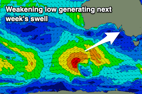
This swell which was looking fairly decent most of this week is now looking a bit weaker, with the low generating it not quite reaching the strength it was forecast to, along with weakening earlier in our swell window.
The low is currently east of Heard Island, generating a mixed fetch of pre-frontal W/NW gales, followed by weaker strong to gale-force W/SW winds over the coming days. The fetch will be aimed mostly in our south-western swell window, but there’ll be some weaker westerly winds aimed through our western swell window, producing some small waves for the Mid Coast.
The swell looks to consist mostly of upper mid-period energy, filling in Tuesday and peaking late afternoon/evening. The Mid Coast should build to 1-2ft on the sets while the South Coast should build to 3-4ft across Middleton. Fresh to strong SW sea breezes will create average conditions on the Mid, swinging back to the S/SE later.
Wednesday will be cleaner on the Mid with a morning SE breeze but the swell will likely be back to 1-1.5ft, onshore down South and easing from 3ft+.
Longer term, weak frontal activity will provide small to moderate levels of mid-period surf through the end of the week and next weekend, but winds look to remain an issue and out of the south. More on this Monday, have a great weekend!