Building surf with a bit of wind, improving through the weekend

South Australian Forecast by Craig Brokensha (issued Wednesday 2nd September)
Best Days: Protected spots South Coast Thursday and Friday, Mid Coast for the keen Friday, Saturday and Sunday both coasts (early Mid Coast Sunday)
Recap
Plenty of size left out of the S/SW yesterday with fun and clean 3ft sets off Middleton, a touch wind affected into the afternoon with stronger offshore winds, small and inconsistent this morning with a continuation of strong offshores.
The Mid Coast has been tiny and choppy with the strengthening N'ly. Our inconsistent W/SW groundswell should build into this afternoon and offer 3ft sets across the Middleton stretch and 1ft to possibly 2ft sets on the Mid as winds shift more NW.
This week and weekend (Sep 3 – 6)
Following the least consistent of the swells this afternoon, we've got large and windy westerly energy on the way through the end of the week and weekend.
A broad, strong mid-latitude frontal progression is moving in from the west with various fetches of winds mostly through our western swell windows.
Currently the weakest of 25-30kt+ W winds are being generated through the Bight, though an embedded low further south is generating stronger W/SW gales but over a tight and small area.
A mix of mid-period W/SW swells will be generated and fill in tomorrow, while at the same time a secondary front pushing through will generate some additional windswell to the mix.
Building surf from 2ft to 2-3ft is expected on the Mid Coast into the afternoon with down South maintaining 2-3ft waves across Middleton all day under strong but easing NW tending W/NW winds.
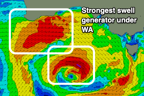
The stronger front will produce larger W/SW groundswell energy on Friday from a stronger fetch of W/SW gales pushing under WA and through the Bight.
The Mid Coast looks to persist around 3ft, if not for the rare bigger one while the South Coast looks to come in around a similar 3ft or so across the Middleton stretch, a touch bigger towards Goolwa.
 Winds will still be onshore though workable for the Mid Coast and moderate out of the W/NW, similar down South and best in protected spots which will be smaller.
Friday's swell will ease into Saturday but a less consistent long-period W/SW groundswell will take its place, generated yesterday and early this morning by fetches of gale to severe-gale W/SW-SW winds east of Heard Island and then projecting towards us.
This should maintain 2-3ft waves on the Mid Saturday, easing Sunday from 2ft though holding with a less consistent reinforcing W/SW swell. The South Coast should offer a touch more size Saturday morning to 3-4ft, then easing and smaller Sunday.
Winds will remain favourable for the South Coast and out of the W/NW for most of the day while the Mid Coast should improve as winds tend lighter NW and even variable late in the day. Sunday looks a touch better for the Mid Coast though still wind affected with a dawn NE'ly, fresher N/NE int the afternoon and clean all day down South.
The longer term revolves around broad and strong frontal systems pushing up and towards WA under the influence of a strong node of the Long Wave Trough. With the fronts projecting north-east towards WA, we'll continue to see swells out of the west and with generally favourable winds, but more on this Friday.