Increasing westerly energy this week

South Australian Forecast by Craig Brokensha (issued Monday 13th July)
Best Days: South Coast magnets tomorrow morning and Wednesday, both coasts Thursday (Mid Coast afternoon) and Friday, South Coast Saturday and Sunday morning
Recap
A fun though bumpy W/SW swell to 1-2ft on the Mid Coast Saturday, improving through the day as winds went variable. The South Coast was a clean and small 1-2ft for keen surfers while Sunday was bumpy and average across both coasts.
Today we've got cleaner conditions but with a tiny 1ft of swell on the Mid, better down South and to 2-3ft with light winds.
This week and weekend (Jul 14 - 19)
These notes will be brief as Ben's on annual leave.
Looking at the coming week and we've got a couple of very inconsistent long-range W/SW groundswells due ahead of a better pulse later week and the best pulse on the weekend.
These swells have been generated by an overactive westerly storm track through the southern Indian Ocean and at more polar latitudes, under the influence of a strong node of the Long Wave Trough.
The first, smallest and least consistent is due tomorrow, offering 1ft sets on the Mid Coast and 2ft sets across Middleton with NE tending E breezes down South and E tending variable winds on the Mid.
Wednesday should be a similar size but with better N/NE tending variable N winds.
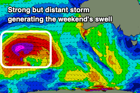
There's been no change to the better pulse of W/SW groundswell for Thursday, with a significant fetch of severe-gale W/SW winds firing up around the Heard Island region, projecting north-east towards Western Australia and aimed mostly at Indonesia.
We'll still see some good though inconsistent W/SW groundswell energy from this source, with it building to 2ft on the sets across the Mid Coast into the afternoon, easing from a similar size Friday while Middleton should see good 3ft sets.
 Winds should hold out of the N/NE to N/NW on Thursday down South, favourable on the Mid and NE tending N but then variable into the afternoon and back offshore late. Friday looks similar though with a touch more strength to the northerly, adding more bumps on the Mid.
Moving into the weekend, the secondary pulse of long-period and inconsistent W/SW groundswell is also on target.
The storm producing this swell will be a touch stronger but follow a similar track to the one generating Friday's swell.
As a result we'll see a similar inconsistent but stronger W/SW groundswell building Saturday and reaching 2-3ft on the Mid Coast, 3-4ft down South though with long waits for the sets.
Unfortunately for the Mid Coast winds will strengthen out of the N-N/NW with an approaching front, shifting NW to W on Sunday as the front moves through. Some low quality swell will generated by this front early next week but with average winds. More on this Wednesday.