Windy XXL swell for the state

South Australian Forecast by Craig Brokensha (issued Monday 29th June)
Best Days: South Coast swell magnets tomorrow, protected spots South Coast Wednesday and Thursday and Friday morning, Mid Coast Saturday and for beginners Sunday, South Coast Sunday
Recap
Good to great waves across both coasts Saturday with Friday's new W/SW swell easing in size back from a fun 2ft on the sets across the Mid Coast, 3ft+ across Middleton, smaller but fun on the swell magnets yesterday morning as the Mid became tiny.
Today the surf is similar and small across the South Coast, best on the magnets, tiny on the Mid.
This week and weekend (Jun 30 – Jul 3)
The surf is due to remain small to tiny tomorrow, though the swell magnets on the South Coast should be fun with a very inconsistent long-range W/SW groundswell filling in from our far swell window.
Don't expect any size at Middleton but gusty N tending N/NW winds will favour these exposed breaks, biggest into the afternoon.
Conditions will be favourable again on Wednesday morning with a fresh N'ly wind, stronger from the N/NW into the afternoon as a new W/SW groundswell fills in. This swell, discussed below will be small in the morning but should reach 3ft on the sets across Middleton into the afternoon.
The Mid Coast will remain tiny tomorrow, but come Wednesday the first in a series of W/SW swell is due to build ahead of our significant XXL W/SW groundswell event into Thursday/Friday.
The source of these swells will be back to back mid-latitude storms projecting up and through our western swell window, under WA under the influence of a strong node of the Long Wave Trough.
The first front is currently moving into our swell window with a fetch of strong to gale-force W/SW winds due to reach severe-gale this afternoon just west of the Bight, dipping east-southeast while weakening slowly tomorrow morning.
A strong W/SW groundswell is due off this initial front, building Wednesday to 3ft on the Mid, but with those poor and strong NW winds. There'll also be some building NW windswell in the mix.
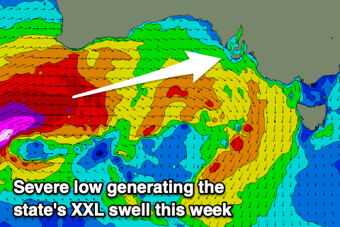 Behind this first storm a much more significant low is forecast to form south-west of WA, projecting severe-gale to storm-force W/SW winds perfectly through our western swell window, on top an active sea state. This low will push under WA and through the Bight while weakening, and then crossing us Wednesday evening.
An XXL W/SW groundswell is due, building rapidly Thursday afternoon, peaking overnight and easing Friday.
Size wise we're due to see the Mid Coast kicking to 3-4ft into the afternoon, then easing from a similar size Friday morning, while with the westerly direction, Kangaroo Island will block a fair bit of the energy. Building surf to 4-5ft is expected along the Middleton stretch through Thursday, easing from 3-5ft on Friday morning.
Local winds will unfortunately be poor for the Mid Coast during this swell event with fresh and persistent W/NW breezes Thursday, NW tending W/NW on Friday ahead of a SW change.
Saturday looks much cleaner as a high moving in brings S/SE offshore winds, but the swell will be half the size and easing from 2ft or so. The South Coast will be poor.
Looking at Sunday and we may see more variable winds and cleaner conditions with a mix of swells to 1-1.5ft on the Mid, 2ft+ across Middleton. Longer term there's nothing too significant on the cards but winds will become favourable for the South Coast with fun waves on the swell magnets. More on this Wednesday.