Good W/SW swell due late week

South Australian Forecast by Craig Brokensha (issued Wednesday 24th June)
Best Days: Both coasts Friday and Saturday, South Coast Sunday morning, South Coast Tuesday desperate surfers
Recap
Poor, cold, onshore and wintry conditions across all locations yesterday, with cleaner conditions this morning on the South Coast with a mix of easing swells from 2ft or so off Middleton. The Mid is still bumpy and 1ft max.
This week and weekend (Jun 25 - 28)
Tomorrow will be a lay day across both coasts with a low point in swell and clean but tiny waves down South with a N/NW-NW breeze ahead of an afternoon W/SW change.
This change will be associated with a weak mid-latitude front pushing in from the west, linked to a fun increase in mid-period swell through Friday. The front will spawn of a stalling mid-latitude low that's currently sitting just south of Western Australia.
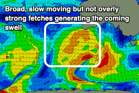 A broad but not overly significant fetch of strong W/SW winds is being aimed through our western swell window with a weakening cold front pushing east towards us this evening and then across us tomorrow, bringing the change.
An afternoon increase in W/SW windswell is expected tomorrow on the Mid Coast but we'll see the swell fill in Friday offering 2-3ft sets on the swell magnets.
The South Coast will build through the day and likely peak into the afternoon to 3ft off Middleton. A slow drop in size should then be seen Saturday from 2ft on the Mid Coast and 3ft off Middleton.
Winds on Friday still look great with local offshore winds for both coasts, E/NE on the Mid and N/NW down South, giving into weak sea breezes and then likely variable later afternoon and into the evening.
Saturday looks a little better on the Mid now with a morning moderate NE breeze, shifting N'ly but then easing late in the day, and N/NE tending variable on the South Coast.
Come Sunday the swell will be smaller and fading from an inconsistent 2ft off Middleton, tiny on the Mid as northerly winds favour the swell magnets.
A low point is due Monday but some inconsistent new W/SW groundswell is on the cards for Tuesday, generated by generally weak, patchy and distant mid-latitude activity west-southwest of WA. The South Coast swell magnets look the go for the desperate with stronger N/NW tending NW winds, but of greater importance is a strong mid-latitude frontal progression firing up mid-late week.
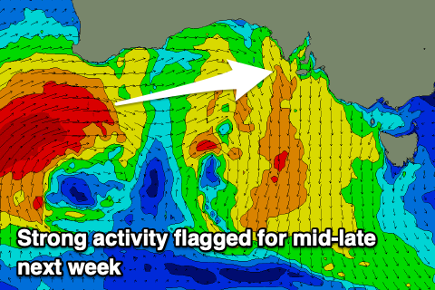 Initially a strong node of the Long Wave Trough sitting across Western Australia will project a series of strengthening and significant mid-latitude storms up into their coast. But as the week progresses the node is forecast to shift slowly east, dragging the activity towards the Bight and through our western swell window.
This looks to bring large and windy swells from the W/SW later week, but check back here on Friday and Monday for a clearer idea.