Small and clean tomorrow, larger and windy swells next week

South Australian Forecast by Craig Brokensha (issued Friday 16th August)
Best Days: Exposed breaks tomorrow, protected spots South Coast Monday for keen surfers, similar on the Mid, South Coast Tuesday, Mid Coast Thursday, South Coast Friday
Recap
Small to tiny and clean waves on offer across the South Coast most of yesterday ahead of a late increase in new building W/SW groundswell. Conditions remained clean and a little blowy with building inconsistent sets to 2ft off Middleton, 3ft to occasionally 4ft across more exposed breaks. The Mid Coast remained tiny and bumpy.
An early offshore wind provided a window of clean conditions down South with inconsistent 2-3ft sets along the Middleton stretch, but a change has since moved through, tiny and bumpy to 1ft on the Mid Coast.
Today’s Forecaster Notes are brought to you by Rip Curl
This weekend and next week (Aug 17 - 23)
Today's inconsistent swell will ease slowly through tomorrow, slowed by the arrival of a new inconsistent long-range SW groundswell, generated by a tight and intense but distant low through the middle of this week.
Easing inconsistent 2ft waves are due along the Middleton stretch, possibly not easing until later in the day, tiny on the Mid Coast and to 0.5-1ft. Waits and Parsons should be better with infrequent 3ft+ sets.
Conditions look favourable with a N/NE offshore through the morning, shifting N/NW through the mid-late afternoon.
Our strong cold front moving through Sunday is still on track, though the timing of the change proper has been delayed slightly, with it due Sunday morning.
 Conditions will be clean in protected spots Sunday morning down South with a gusty W/NW breeze, but the swell will small to tiny. The Mid Coast will be tiny early, with building windswell to 2ft+ through the day, if not for 3ft sets later as winds shift W-W/SW.
A mix of mid-period W/SW swell and new SW groundswell are still due on Monday, the former generated by an elongated fetch of strong W/SW winds south of WA this evening and tomorrow.
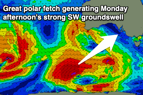
A much better polar fetch of gale to severe-gale W/SW winds are being generated, with the low linked to this expected to move slowly east while weakening tomorrow.
A moderate to large long-period SW groundswell will be generated by this source, filling in Monday and peaking through the middle of the day/afternoon.
The Mid Coast should see 3ft surf on Monday from the W/SW source, while Middleton will build to 4-5ft+ from the SW groundswell.
Winds unfortunately look onshore and moderate to fresh from the W/SW for the most part, possibly W'ly early around Victor in the morning.
Tuesday looks much better with a moderate to fresh W/NW wind and easing swell from 4-5ft across Middleton, 2ft to possibly 3ft on the Mid Coast.
The rest of the week will consistent of moderate levels of mid-period swell as further strong cold fronts move in from the west, but fetch strength isn't expected to reach the gale-force range at this stage.
As a result it'll be sizey out of the W/SW tending SW, but not overly strong in power, mixed in with some smaller and less consistent W/SW groundswell from strong storms in the Indian Ocean.
Winds will shift onshore and out of the SW on Wednesday, S'ly into Thursday as a strong high moves in after the frontal activity. This will create poor conditions down South, but cleaner waves on the Mid Coast with sets to 2ft Thursday. A front approaching from the west will push the high east and swing winds N/NE with fun easing sets from 3ft on the South Coast, tiny on the Mid.
Longer term some good new groundswell is due early the following week, but more on this Monday. Have a great weekend!