Great period for the South Coast from late week

South Australian Forecast by Craig Brokensha (issued Wednesday 5th September)
Best Days: South Coast Friday through Tuesday next week (biggest and best Monday), Mid Coast Friday, early Saturday and Monday
Recap
Good waves down South all day yesterday, a little lumpy early but improving through the day as offshore winds ironed it out. There were good sized sets on offer at Middleton, before easing into the afternoon and back to a small 1-2ft this morning. We'll see the swell continuing to fade through the day under a fresh offshore wind, while the Mid Coast has been tiny and poor.
Today’s Forecaster Notes are brought to you by Rip Curl
This week and early next week (Sep 6 – 11)
Tomorrow is looking average across both coasts, with the swell due to start tiny across the South Coast with a morning W/NW breeze, giving into an afternoon W/SW change as some better W/SW groundswell starts to show.
The Mid Coast will see a building W/SW swell but with poor conditions, reaching 2ft+ through the day and quite weak in nature.
Friday is looking the better surf day with a mix of mid-period and long-period W/SW groundswell peaking.
The long-period energy has been generated since late last week by a strong and slow moving polar frontal progression through the southern and south-east Indian Ocean.
The remnants of this progression have then moved through the Bight, generating strong W/SW winds under WA and through our western swell window, producing the mid-period swell.
The additional SW swell for the South Coast has been downgraded with a very small and weak fetch forming south-southwest of the region, aimed towards Tasmania.
So we can expect 2-3ft waves on the Mid Coast Friday with Middleton coming in at an infrequent 3ft to possibly 4ft.
Winds looks good for the South Coast and offshore from the W/NW-NW for most of the day, while the Mid Coast will be workable as well with the winds being only light to moderate in strength.
We should see both swells easing through Saturday with a fresh N/NW tending W/NW breeze (likely N/NE early on the Mid Coast) with sets dropping from 3ft along the Middleton stretch and 2ft on the Mid Coast.
As touched on last update, with got a good run of swell on the cards with favourable winds early next week as a strong node of the Long Wave Trough develops and stalls across southern WA.
We'll see a flurry of vigorous polar fronts projected up and towards WA, generating moderate to large pulses of groundswell.
The first and weakest front will form around Heard Island today, producing an initial fetch of W/SW gales, weakening while broadening and projecting through the Bight on Friday.
This should produce a mid-period SW swell for Sunday coming in around 3ft along the Middleton stretch and 1-2ft on the favourable parts of the tide across the Mid Coast. Winds will persist from the W/NW, favouring the South Coast over the Mid.
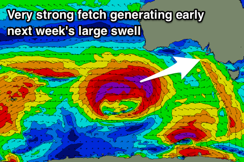 A much stronger and more northerly positioned storm will generate a fetch of severe-gale to storm-force W'ly winds through our western swell window, before being deflected south-east away from us during Saturday evening.
A large and long-period W/SW groundswell will result, arriving overnight Sunday and peaking Monday.
The Mid Coast should see 3ft sets, with 4-6ft sets off Middleton and winds will be excellent for the South Coast with a persistent and moderate to fresh N/NE-N offshore.
Tuesday looks great as well as the swell eases under N'ly offshores ahead of a W'ly change. Beyond this there's plenty more W/SW swell on the cards, but more on this Friday.