Relatively average weekend with a large building groundswell

South Australian Forecast by Craig Brokensha (issued Friday 31st August)
Best Days: Early Saturday protected spots down South for keen surfers, Tuesday swell magnets South Coast
Recap
A good new increase in groundswell across the South Coast yesterday morning but with bumpy conditions with a fair bit of east in the wind. The afternoon was much better as winds straightened and the swell eased off just a touch.
This morning was a bit smaller but super clean again and best at Waits and Parsons. A new S/SW groundswell should fill in this afternoon but with average conditions following a W/SW change. The Mid Coast has been tiny to flat, increasing slightly today, and we'll se some windswell building this afternoon behind the change.
Today’s Forecaster Notes are brought to you by Rip Curl
This weekend and next week (Sep 1 - 7)
This afternoon's first pulse of S/SW groundswell will be reinforced by a secondary similar sized swell tomorrow morning, generated by post-frontal W/SW gales following a pre-frontal W/NW fetch.
Middleton should see inconsistent 3ft sets, while the Mid Coast will see a drop in windswell back from 1-1.5ft or so.
It looks like we'll see a window of early W/NW winds on the Surf Coast ahead of a S/SW change as a cold front from a strong polar storm clips us.
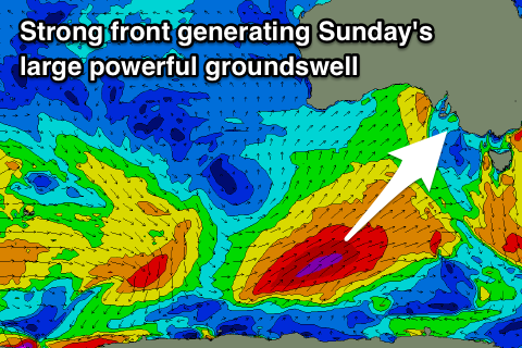 This polar storm developed yesterday afternoon, south-southwest of WA and has already produced a fetch of W/SW gales through our swell window.
Models have upgraded the core wind speeds within this fetch and we'll see severe-gale SW winds projected through our southern swell window tomorrow and then across Tassie on Sunday.
We'll see a large and powerful S/SW groundswell for Sunday, building rapidly through the day and reaching an easy 6ft across Middleton and other locations around Victor, while the direction isn't ideal for the Mid Coast with tiny 1t+ surf due.
Winds on Sunday will improve but still remain less than ideal for the South Coast with a light E/SE tending E'ly breeze and lots of leftover lump and wobble from overnight onshores.
A slow moving high will move in from the west during next week, and this will result in a slow improvement in winds as the surf eases, while also blocking any other major swell producing systems until later week.
E/NE-NE winds will create cleaner peaky waves on Monday as the S/SW groundswell drops from the 4-5ft range off Middleton.
Tuesday looks like the best day to surf with a straighter offshore N/NE wind and easing swell from 3ft on the sets off Middleton, back to 2ft into the afternoon, more size and power at Waits and Parsons.
Wednesday looks like a lay day with stronger offshore winds and a low point in swell, with a new long-period W/SW groundswell due to fill in Friday.
The groundswell will be generated by a vigorous and slow moving polar frontal progression through the southern Indian Ocean this weekend and early next week.
The progression will project towards WA resulting in a moderate to large W/SW groundswell for later next week. We may see a mid-latitude spawn off the front and push east with the swell, bringing poor winds and an additional windswell, but more on this Monday. Have a great weekend!
Comments
Southern tip of WA seems to attract so much swell.
A bit more size than expected across the Mid this afternoon. 2ft sets..