Back to back oversized W/SW groundswells inbound

South Australian Forecast by Craig Brokensha (issued Monday 16th July)
Best Days: South Coast Tuesday, Wednesday and Thursday morning (experienced surfers only), Saturday and Sunday South Coast, Mid Coast early Saturday
Recap
Pumping waves across the entire South Coast on Saturday with a strong new long-period SW groundswell and all day offshores, back to a smaller 2-3ft on Sunday and nice and clean again.
The Mid Coast was tiny and poor all weekend, with the most size seen through yesterday to 1-1.5ft.
This morning we've reached a low point in swell activity, but some new SW groundswell is due later today and should kick Middleton to 2-3ft by dark as winds persist from the NW.
Today’s Forecaster Notes are brought to you by Rip Curl
This weekend and next week (Jul 17 - 22)
Want to receive an email when these Forecaster Notes are updated? Then log in here and update your preferences.
Looking at the current synoptic pattern and to our west we've got a broad and elongated frontal system aiming a fetch of gale to severe-gale W/SW winds through our western swell window.
This is the same front that over the weekend, generated a storm-force fetch of W/SW gales on top an active sea state while projecting east-northeast towards us.
An XXL W/SW groundswell has been generated which will impact exposed west and south-west facing coasts, arriving across our regions on Wednesday.
Ahead of this though an inconsistent long-range groundswell is expected across the South Coast tomorrow morning, providing infrequent 3ft+ sets, while through the day some new mid-period W/SW swell should also fill in, produce by broad W'ly gales under WA yesterday and this morning.
Middleton should reach just over 4ft later in the day under NW tending W/NW winds, and possibly W/SW-W through the afternoon.
The Mid Coast is looking at a stormy 2-3ft of NW windswell in the morning, with a mix of mid-period energy and windswell building through the afternoon more to 3ft+.
Moving into Wednesday and the oversized long-period W/SW groundswell will fill in, peaking through the late afternoon/evening.
The models are incorrectly combining the large mid-period energy with the building long-period swell, and this can be seen in the model guidance on Wednesday.
At 12am/midnight Tuesday, there's 3m of mid-period W/SW swell at 14.8s and 1.3m of 20.6s swell. Both swells are then incorrectly combined at 6am Wednesday, resulting in an over-forecast of the open ocean swell energy with it showing 3.6m at 19.7s.
This is not the case with the long-period energy building through the day and peaking into the late afternoon/evening.

Size wise Middleton is expected to build to 8ft+ through the mid-late afternoon, with larger sets at deepwater reefs, smaller and more around 4-5ft+ in the morning. The Mid Coast will be larger and likely building from 3ft+ in morning, more to 4-5ft into the late afternoon with the big incoming tide.
Winds will be best for the South Coast and excellent (poor on the Mid) with a fresh to strong and persistent NW'ly.
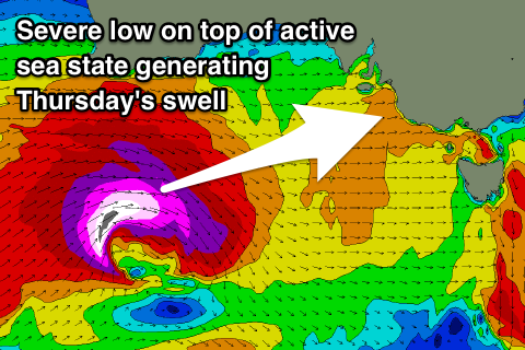 Moving into Thursday and we've got a secondary large long-period W/SW groundswell due across the region.
This will be generated by a secondary severe-low develop in our western swell window, south-west of WA tomorrow morning, projecting a fetch of storm-force W'ly winds on top of another active sea state.
More consistent, large surf should be seen across our state Thursday morning, coming in around the 8ft range again across Middleton. The Mid Coast looks to hang in at 3-4ft but our window of favourable winds looks small, with a gusty morning NW'ly, giving into a SW change around midday/early afternoon.
Lingering onshore SW winds are likely into Friday with the surf slowly easing but still large.
The weekend is looking great again though, with a moderate to large reinforcing SW tending S/SW groundswell due into Friday afternoon, easing Saturday and Sunday, produced on the backside of storm producing Thursday's swell.
A broad fetch of gale to near severe-gale W/SW-SW winds are forecast to be projected towards us through the middle to end of the week, and this should keep Middleton up around 4-6ft Saturday morning, easing under N/NW winds all weekend.
The Mid Coast looks to ease steadily from 2ft to maybe 3ft Saturday morning, with a possible early N/NE breeze, but we'll review this Wednesday.