Windy showery week of waves
South Australian Forecast by Craig Brokensha (issued Monday 3rd July)
Best Days: South Coast Tuesday, Thursday and Saturday
Recap
Great waves across the South Coast Saturday with a fun sized and easing swell, while yesterday was much smaller and only good at swell magnets.
The Mid Coast was tiny and bumpy all weekend, kicking up a little into yesterday afternoon.
Today a new W/SW groundswell due across the state hasn't really come in at all across the South Coast with small clean 1-2ft waves off Middleton, while the Mid Coast was also small and under-forecast. A building stormy NW windswell has since developed across the Mid Coast though along with strong NW winds as an intense but weakening mid-latitude low pushes east across us.
This week and weekend (Jul 4 - 9)
Today’s under-performing W/SW groundswell will ease off through tomorrow and further into Wednesday morning along with the windswell from the mid-latitude low that's currently north of us. This low will become much weaker into tomorrow, resulting in a rapid drop in windswell across the Mid Coast.
Middleton should see 2-3ft sets in the morning tomorrow, back to a smaller 1-2ft early Wednesday.
The Mid Coast should see easing sloppy and choppy waves from the 2ft range along with moderate to fresh W/NW winds. These winds will favour protected spots down South, with Wednesday coming in similar with a possible early W/NW'ly down South, giving into a W/SW change through the day.
Into Wednesday afternoon we should see a new SW groundswell filling in down South, and to a lesser degree on the Mid Coast.
This swell was generated late last week and over the weekend by a very strong and powerful polar low. The low was strongest way on the edge of our swell window, west of Heard Island and weakened slightly while moving east along the polar shelf.
With this there'll be very long waits between sets, with the swell due to reach 3ft by dark at Middleton Wednesday, peaking Thursday morning to 3-4ft.
The Mid Coast is likely to see some weak W/SW windswell to 1ft+ Wednesday afternoon, with the groundswell not topping this Thursday.
Winds on Thursday look great with an approaching mid-latitude front bringing fresh N/NE tending N/NW breeze.
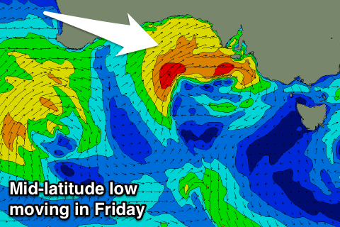
Now, this approaching frontal system will take the form of an intense mid-latitude low as it moves across us late week.
 The system will start as a polar front projecting towards WA, before pushing through the Bight and re-intensifying off our West Coast.
A fetch of strong to gale-force W/SW winds will be projected into the Mid Coast, kicking up stormy 2-3ft waves for Friday but with strong W/NW tending W/SW winds, easing into Saturday.
The windswell looks too north for the South Coast, with some W/SW swell building later in the day to 2-3ft at Middleton but with those onshore W/SW winds.
Saturday looks better as the swell persists at 2ft to occasionally 3ft with NW winds.
Into Sunday a new long-range SW groundswell is due, generated by a pre-frontal polar fetch of NW gales through our swell window over the coming days.
Similar 2-3ft waves are due across Middleton again with fresh N/NW offshores, small and choppy on the Mid Coast, but more on this Wednesday.

