Great conditions and good swells this week

South Australian Forecast by Craig Brokensha (issued Monday 11th June)
Best Days: Every day down South until Saturday afternoon, Mid Coast Thursday and Friday morning
Recap
Great waves across both coasts over the weekend with clean 3-4ft surf off Middleton Saturday morning, back to the 2-3ft range Sunday. The Mid Coast saw Friday's strong W/SW groundswell dropping back to 2ft Saturday, tiny and around the 1ft range yesterday.
Today an inconsistent long-range swell has kept Middleton around 2-3ft with offshore winds, while the Mid Coast hovered around 1ft with less than ideal winds.
This week and weekend (Jun 13 – 18)
We should see wave heights steady through tomorrow with a continuation of inconsistent long-range SW groundswell mixed in with some mid-period energy from fronts passing under as the last couple of days.
Inconsistent sets to 3ft should continue off Middleton with 1ft waves on the Mid Coast, easing back into Wednesday morning.
Conditions are looking great most of tomorrow down South with a light offshore wind, tending variable into the afternoon.
 Wednesday will then see moderate to fresh N/NE tending N/NW winds, favouring the South Coast again, and into the mid-late afternoon we should see the first signs of long-period SW groundswell.
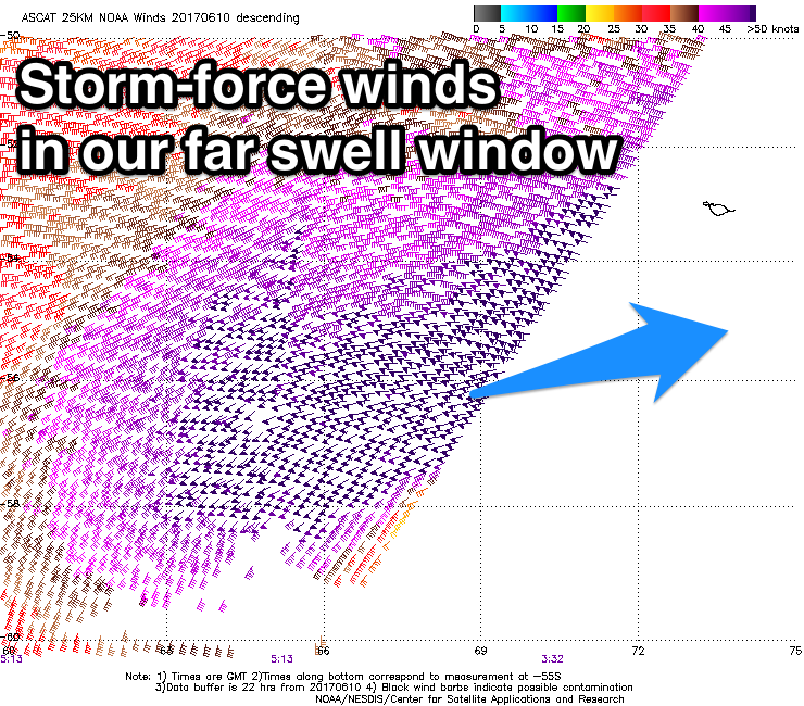
Over the weekend satellite observations confirmed a significant fetch of storm-force W/SW winds generated in our far south-western swell window, and since we've seen a secondary front moving over the active sea state, closer towards WA and in our western swell window.
This front will then weaken and dip south-east under the Bight, but maintain a fetch of strong to gale-force W/SW winds.
What we should see is the inconsistent but long-period energy arriving from the SW Wednesday afternoon, building to 3-4ft by dark across Middleton on the sets and 1ft+ across the Mid Coast.
A peak is expected Thursday, but the W/SW swell will also fill in into the afternoon providing more size on the Mid Coast. Middleton should see 4-5ft sets Thursday, with long waits between them, while the Mid Coast is due to be around 1-2ft through the morning, building to 2ft+ into the afternoon.
A slow drop in size is then due Friday from 2ft on the Mid Coast and the 4ft range on the sets across Middleton.
Light local offshores are due Thursday morning (NE on the Mid and N'ly down South) tending variable into the afternoon, with similar conditions Friday. This will create great surf right across the region and state.
Into the weekend we'll see the swell continue to ease, slowed by some reinforcing SW energy from pre-frontal W/NW fetches moving through our south-western swell window.
The timing of an onshore change looks to be later rather than earlier at this stage, with clean conditions down South before a strong SW'ly kicks in.
This onshore change will be linked to a strong cold-outbreak across the south-east of the country with onshore storm waves due Sunday and Monday, but more on this Wednesday.
Comments
22.3s forerunners picked up on the Cape du Couedic wave buoy. Bulk of the swell isn't due until this evening and more so tomorrow morning mixed in with the secondary building W/SW swell.