Excellent Thursday, wishywashy swells until next week

South Australian Forecast by Craig Brokensha (issued Wednesday 20th July June)
Best Days: Thursday down South, Friday morning down South, Saturday afternoon Mid Coast, Sunday morning and Monday South Coast
Recap
Great waves across the Mid Coast the last couple of days with clean 2ft sets, while the South Coast saw good 2-3ft surf yesterday off Middleton, kicking a touch into the afternoon.
Today a stronger SW groundswell has provided larger 4ft sets across the region but E'ly winds are making for less than perfect conditions.
This week and weekend (Jul 21 - 24)
 Tomorrow is looking excellent across the South Coast, with the strongest pulse of SW groundswell due to fill in under moderate to fresh N/NW winds.
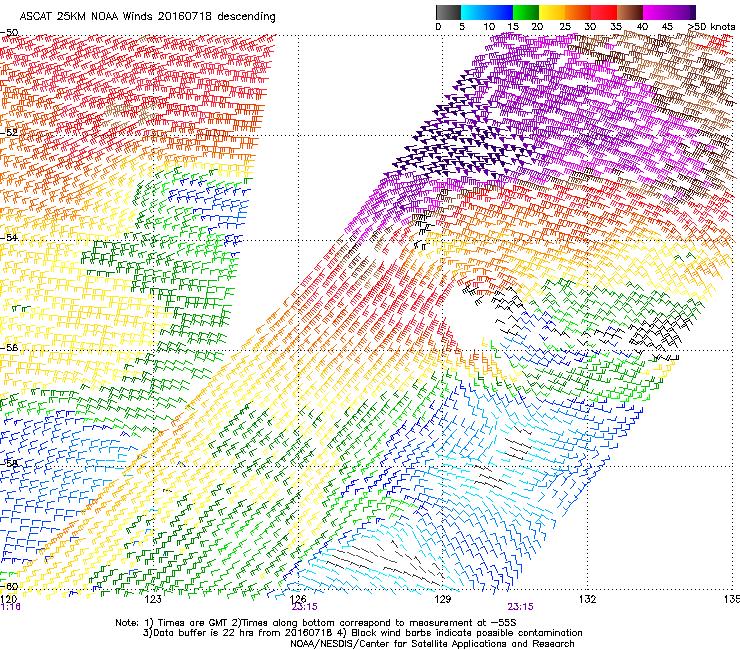
This swell was generated by a stronger mid-latitude front firing up on the back of the system linked to today's swell, but stronger storm-force winds were recorded at the core of this second system (right).
We should see Middleton come in at 3-5ft tomorrow morning with larger 6ft+ sets at Waits and Parsons, while the Mid may see 1ft to occasionally 2ft sets continuing.
As touched on above, winds will be best for the South Coast and offshore all day but bumpy on the Mid.
Easing surf from 3ft across Middleton is due Friday with strengthening NW tending W/NW winds. Our models have a late increase in size, but this isn't expected with a weak windswell not building above the existing groundswell.
This will kick up a building W/NW windswell across the Mid Coast which should build from 1-2ft through the morning to 2ft+ later in the day.
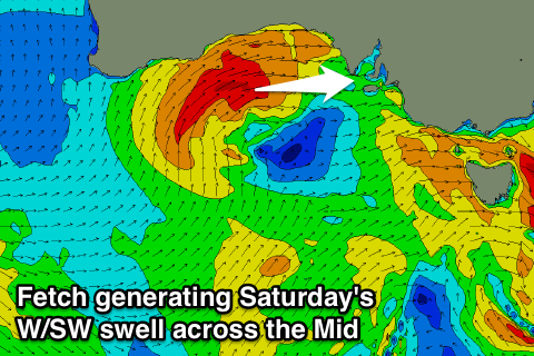 Into the weekend we'll see the stronger frontal system pushing in through the Bight Friday kicking up a solid increase in W/SW swell for the Mid Saturday. We should see onshore 3ft waves, workable into the afternoon with fresh but easing SW tending W/NW winds.
The South Coast won't see much size or power, with the fetch pushing through the Bight being too north in latitude to generate any major size, while a weaker fetch of strong SW winds will be aimed through our swell window Saturday.
This should produce a building short-range S/SW swell later Saturday to 3-4ft at Middleton, much smaller early, easing from a similar size Sunday morning. Winds will improve into Saturday afternoon when tending W/NW, while Sunday is cleaner but windy with a strong N/NW tending W/SW breeze.
These strong winds will be linked to another vigorous mid-latitude low pushing in from the west, kicking the Mid Coast back to a stormy 3ft into the afternoon, with the South Coast seeing more size Monday morning to 4-5ft at Middleton. W/NW winds Monday will then favour the South Coast again.
Next week onwards (Jul 25 onwards)
 While Monday's looking good in protected spots down South, there's much larger and better swells to come through next week.
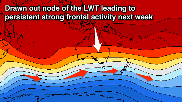
A series of vigorous polar fronts will fire up one after the other under the influence of an elongated node of the Long Wave Trough stretching across us, Victoria and New Zealand.
A series of large long-period SW groundswells are on the cards along with favourable W/NW winds for the South Coast from Wednesday, but more on this in Friday's update.
Comments
Love the random stills our surfcam picks up from time to time. Old mate hooking it under the lip in the Bay a short time ago.
How's those lines!