Solid building swell Friday but with onshores, easing slowly all weekend

South Australian Forecast (issued Wednesday 24th February)
Best Days: Protected spots tomorrow morning down South, Mid Coast later Friday and Saturday morning, South Coast Monday and Tuesday mornings
Recap
Good clean conditions most of the day down South yesterday with a fun new swell to 2-3ft at Middleton, bigger out at Waits and Parsons. Similar surf was seen this morning with light variable tending offshore winds and fun amounts of swell. The Mid Coast has been tiny to flat but generally clean.
This week and weekend (Feb 25 - 28)
South Coast: A dropping swell is due through tomorrow and besides early, conditions will be best in protected spots with a morning WNW'ly due to swing SW through the day. Middleton should be easing from 2ft+ with bigger sets out at Waits.
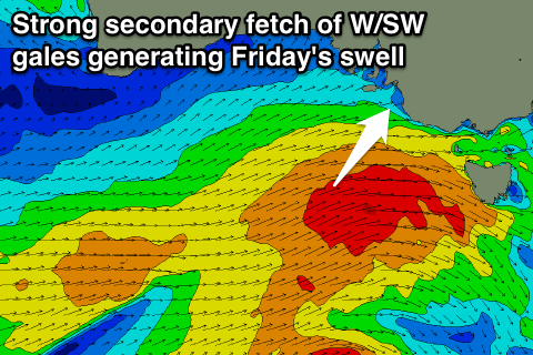 This SW change will be linked to a vigorous secondary intensification of a strong polar front currently pushing up towards us.
This system has been upgraded a touch since Monday and with this we'll see a strong increase in SW groundswell through Friday from 3ft+ at Middleton through the morning to 4-5ft into the afternoon with larger 6ft+ sets at Waits and Parsons.
A secondary reinforcing SW pulse is due Saturday morning from a small embedded low on the tail of the progression racing under us Friday.
This should keep 3-5ft sets hitting Middleton through the morning with 6ft sets at Waits and Parsons, easing a touch later in the day and then more noticeably through Sunday from 3ft+ and 5ft respectively.
Unfortunately winds are still looking poor with fresh SW winds Friday, moderate to fresh but easing from the S'th Saturday and then moderate S/SE Sunday.
There's a slight chance for an early W'ly Friday morning, but don't count on it.
Mid Coast: Tiny surf should continue through tomorrow, but Friday afternoon's pulse should reach 2ft on the sets, easing from 2ft or so Saturday morning and 1ft+ Sunday morning. Morning S/SE winds should be seen Saturday morning and SE winds Sunday, but we'll confirm this Friday.
Next week onwards (Feb 29 onwards)
South Coast: As touched on Monday, a strong long-period S/SW groundswell is due Monday, generated by an intense polar low firing up to our south-west through the weekend. A fetch of severe-gale W/SW winds should produce a kick in size Monday afternoon to 3-4ft at Middleton and 5ft at Waits.
Winds are still dicey but could tending lighter E/NE, with Tuesday much better as the swell eases under N'ly winds.
Mid Coast: Tiny surf is due into the start of next week, with Monday's swell being too south in nature. Longer term there's nothing major due until later in the week, but more on this Friday.