Small ahead of some good new swell Thursday/Friday with light winds

South Australian Forecast (issued Monday 18th December)
Best Days: Swell magnets tomorrow morning, South Coast Thursday and Friday mornings (Mid Coast tiny peelers Thursday and Friday)
Recap
Sloppy waves down South Saturday morning with a fresh E'ly wind and 2-3ft of weak swell, while Friday's Mid Coast swell dropped back to a tiny 0.5-1ft as the predominant swell direction swung more southerly.
Sunday was the day to surf down South with offshore winds and a small swell best suited to Waits and Parsons.
This morning a new small S/SW swell has kept fun 2ft sets hitting Middleton with bigger waves at Waits and Parsons under morning offshore winds. The Mid Coast is effectively flat.
This week (Jan 19 - 22)
South Coast: A small reinforcing SW swell is due tomorrow morning, keeping inconsistent 2ft sets hitting Middleton with 3ft+ waves at Waits and Parsons under morning N/NE winds. Afternoon sea breezes and a drop in swell will create average conditions post midday.
Wednesday morning will start small and winds are a little tricky with a weak surface trough sitting over the region, resulting in likely variable winds early ahead of a freshening S/SE'ly.
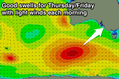
During the day though a strong new S/SW groundswell is expected to build, ahead of a peak Thursday.
This will be the first of two pulses due through this week, linked to a strong polar frontal progression that's already fired up to the south-west of WA.
 Last week the models were having trouble grappling with the strength and development of this progression, but we're now looking at a decent swell generating system.
An initial fetch of pre-frontal W/NW gales is now being followed by a post-frontal fetch of W/SW gales, which will project north-east favourably through our swell window. This should generate a moderate sized SW groundswell for Thursday, while a secondary weaker system firing up on the tail of the original progression will generate a secondary reinforcing S/SW swell for Friday afternoon, easing into the weekend.
Middleton is expected to see solid 3-4ft+ waves Thursday with 5-6ft sets at Waits and Parsons, before dropping back a touch into Friday more to the 3ft+ range with 4-5ft sets at Waits and Parsons.
Winds are looking to remain tricky but likely variable and light offshore both Thursday and Friday mornings ahead of afternoon sea breezes.
Mid Coast: Tiny to flat surf is due through tomorrow and Wednesday mornings, with a possible late kick in new SW groundswell to 1ft. Thursday should see inconsistent 1ft+ sets on the favourable parts of the tide, backing off to 1ft or so Friday.
This weekend onwards (Jan 23 onwards)
South Coast: Friday's reinforcing S/SW swell should ease back through the weekend, with a smaller reinforcing SW swell just slowing this trend through Saturday afternoon and Sunday morning.
Conditions are looking average though as a high pressure ridge moves in from the west bringing S/SE winds Saturday, persisting through Sunday.
Mid Coast: Tiny 0.5-1ft waves are due most of the weekend from the mix of easing swell from Friday and slight reinforcing SW swell. Clean conditions each morning will provide a good option for beginners on the beaches.
Longer term a large blocking high will slowly move in from the west, deflecting any major swell generating systems away from us while also bringing relentless S/SE winds most of next week. More on this Wednesday.