Good Mid Coast later Thursday and Friday morning

South Australian Forecast (issued Wednesday 13th December)
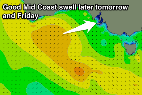
Best Days: Later tomorrow and Friday on the Mid, keen surfers down South Saturday and Sunday mornings, Monday morning down South
Recap
Small lumpy waves across the South Coast yesterday morning with a light variable wind from the SE ahead of stiff sea breezes. The Mid Coast saw the odd 0.5ft set for beginners around low tide on the beaches.
A new SW groundswell kicked through the afternoon and has held well into this morning with clean 1ft sets on the Mid and better clean 2-3ft surf at Middleton with Waits and Parsons the pick for experienced surfers.
This week and weekend (Jan 14 - 17)
South Coast: An onshore change due this afternoon linked to a strong mid-latitude low pushing in from the west will bring with it a mix of new W/SW groundswell for the Mid and SW tending S/SW swell for the South Coast.
 The size of the S/SW swell has been downgraded a touch due to the low moving quickly east with a short-lived fetch of S/SW gales being produced in our southern swell window.
A mix of windswell and groundswell will build tomorrow but with poor S'ly winds, peaking Friday from the S/SW to 3ft+ across Middleton and 4ft at Waits and Parsons with moderate to fresh E/SE tending S/SE winds.
Better E/NE winds are due Saturday morning with easing weak levels of S'ly swell from 3ft across most locations, strongest at Waits and Parsons.
Sunday morning is looking even cleaner with N/NE offshores but the morning will be small with 1-1.5ft sets at Middleton and 2ft+ waves at Waits and Parsons.
Later in the day, a new S/SW groundswell is expected, easing Monday morning, from an unfavourably east-southeast tracking but tight and intense polar front/low.
A fetch of severe-gale W/SW winds will be generated in our swell window, producing a small S/SW swell, building later Sunday with afternoon S/SE sea breezes, peaking overnight and easing Monday morning.
Middleton should see 2-3ft sets early, with 3-4ft waves at Waits and Parsons under offshore N/NE winds ahead of a late onshore change.
Mid Coast: Tomorrow is expected to start tiny, but a strong pulse of W/SW groundswell is due later in the day from the mid-latitude low, kicking to 2ft+ with the incoming tide into the evening.
Conditions should improve as well with fresh S/SW winds expected to tend more S/SE later in the day.
Friday should see the W/SW swell ease back from 2ft+ or so with offshore E/SE tending S/SE winds.
Into the weekend fading 1ft+ surf is due, becoming near flat into Sunday.
Next week onwards (Jan 18 onwards)
Unfortunately our strong pulse of groundswell due mid-week has changed since the last update, with the vigorous polar frontal progression due to generate it now splitting in two, with a mid-latitude low off WA, and weaker polar front through the Southern Ocean.
In saying this both systems are due to approach us into the second half of next week, likely bringing a stormy increase in SW swell, but more on this Friday.
Comments
Looking super fun on the Mid this morning.
Still looking the goods!
Sundays hopefully has a little wave ?
That long period energy doesn't have much size to it Cam, Monday is the better bet.