Fun weekend, good again from Wednesday next week

South Australian Forecast (issued Friday 9th October)
Best Days: Saturday and Sunday mornings down South, Wednesday morning down South, Thursday down South, early Friday down South
Recap
Good fun waves across the Mid yesterday with 2ft sets and clean conditions all day, while the South Coast improved with E/NE winds through the morning before sea breezes kicked in.
Today the South Coast was much better with peaky and fun 3ft of swell across the Middleton stretch with more size out at Waits, while the Mid was back to a tiny 1ft or so, pulsing a little now with the incoming tide.
This weekend and next week (Oct 10 – 16)
 There's been no real change to the weekend's forecast with a fun but smaller SW swell due down South tomorrow, easing back into the evening and Sunday morning. Middleton should still offer 2ft to 3ft sets from Cliffs eastwards, with Waits and Parsons providing bigger 3ft to occasionally 4ft sets. The Mid is only due to be around a tiny 1ft.
Sunday then looks smaller with 1-2ft sets across Middleton and 2ft to sometimes 3ft sets at Waits and Parsons. A new SW groundswell is due to arrive later in the day but this will be average with onshore SW winds.
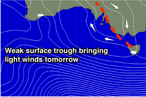
Coming back to tomorrow though, both coasts should be clean and glassy with variable breezes (tending light offshore) as a weak surface trough lies across us, before afternoon sea breezes kick in. Sunday morning should again offer variable winds, increasing from the SW during the day as the surface trough starts drifting east.
The SW groundswell due later Sunday should peak Monday morning, produce by a healthy fetch of W/NW gales currently pushing under the country.
Unfortunately winds will remain poor in the wake of Sunday's change with a S/SW tending S/SE breeze. The Mid should offer better conditions but only tiny 1ft waves for beginners.
Tuesday will be no better with SE winds due to persist across the South Coast as the swell eases. There's a chance a new high will move in quicker than forecast resulting in E'ly winds, but we'll review this Monday.
Into the second half of the week, winds are expected to swing offshore, with some new fun SW swell due into later Wednesday and Thursday.
This will be generated by distant frontal activity in the Indian Ocean, followed by weak fetches of W/NW winds moving in under the country early next week.
Size wise, inconsistent 2-3ft sets are due across Middleton Thursday morning, with 3-4ft+ sets at Waits and Parsons, while the Mid should see tiny 1ft waves.
Following this a very inconsistent long-range SW groundswell from the south-west Indian Ocean is due Friday, mixed in with closer-range energy but winds look to give into a change. More on this Monday though, have a great weekend!