Good period for the South Coast, great weekend

South Australian Forecast (issued Wednesday 12th August)
Best Days: Every day down South, best Friday and over the weekend
Recap
Poor onshore waves across the Mid with a building mix of swells, while the South Coast was fun with a good amount of swell and fresh to strong offshore winds.
Today a strong low was right on our doorstep at dawn with early W'ly winds and a small mix of swells across both coasts, but the system has since pushed across us bringing strong SW winds and building levels of stormy swell on the Mid and also across the South Coast.
This week and weekend (Aug 13 - 16)
The low currently pushing across the region is linked to a large and strong W/SW groundswell which is due to build through this afternoon and then ease as it passes overnight.
Conditions will improve across both coasts tomorrow with easing 2-3ft waves on the Mid while the South Coast should ease from 3-4ft at Middleton with 5-6ft sets at Waits under W/NW tending W'ly breezes.
 A reinforcing S/SW groundswell is due overnight tomorrow, easing Friday from a strong polar frontal system currently pushing up towards Victoria. This should ease from 3-4ft across most locations with 5ft sets at Waits with dropping 1ft to possibly 2ft sets on the Mid. Conditions will be better down South with a NW tending variable W'ly breeze.
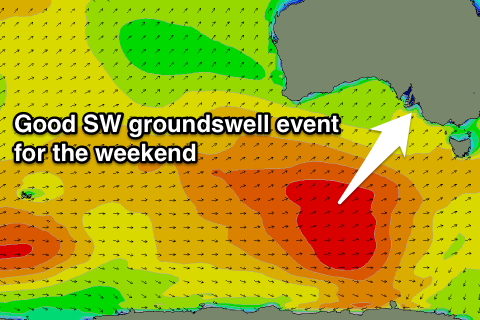
The weekend is still looking great, with a strong new SW groundswell due to build through Saturday and then ease Sunday under offshore winds.
This groundswell is being generated by a strong polar frontal progression that's developed south-west of WA and will produce a fetch of pre-frontal W/NW and then post-frontal W/SW gales while moving under the country the coming days.
The swell is due to build strongly through Saturday from 3ft at Middleton and 4-5ft at Waits to the 4ft and 6ft range respectively through the afternoon under light N'ly tending variable winds. The Mid isn't due to see much size with infrequent 1ft to possibly 2ft sets later Saturday, fading Sunday.
The South Coast will again be solid Sunday morning with 3-4ft waves at Middleton and 5-6ft sets at Waits, easing through the day with N/NW winds.
Next week onwards (Aug 17 onwards)
Monday morning will be smaller again and with only a short period of offshore NW winds ahead of a SW change late morning.
This will be linked to a strengthening polar front pushing up and into Victoria, producing a new moderate sized S/SW groundswell for later in the day and more so Tuesday. Winds are looking dicey Tuesday as a deepening surface low moves in from the west bringing fresh to strong NE winds, but we'll have a closer look at this Friday.