Easing swell with improving winds, great weekend

South Australian Forecast (issued Wednesday 5th August)
Best Days: Protected spots down South Thursday morning, Friday down South, Saturday onwards down South (excluding Sunday afternoon when the swell will bottom out)
Recap
Great large waves down South yesterday with NW-W/NW winds and good options around the Chiton Rocks region. The Mid was average and bumpy with 1-2ft of swell.
Today a new S/SW swell is building across the South Coast but with average W/SW winds early, which have swung more SW through the day.
This week and weekend (Aug 6 - 9)
Today's onshore change is linked to a strong polar front pushing up and into the south-east of the country, producing a final large S/SW groundswell for us this afternoon, peaking overnight and easing tomorrow.
Middleton should ease from 4-6ft tomorrow morning with 6-8ft sets at Waits and Parsons and 1-2ft waves on the Mid.
The easing trend will be slowed into Friday from a persistent fetch of S/SW winds through our swell window on the backside of the frontal progression, with a final inconsistent S/SW groundswell filling in Saturday afternoon.
Winds tomorrow will be similar to today and from the SW, but the Victor region should see an early W'ly favouring protected locations.
Friday will be much cleaner with variable winds and a dropping swell from the 4ft range at Middleton and 5-6ft at Waits and Parsons.
 The weekend looks great, and biggest Saturday with light offshore tending variable winds and the mix of S/SW swells to 3ft at Middleton and 4-5ft at Waits and Parsons. A noticeable drop will be seen Sunday though from 2ft+ at Middleton and 3-4ft at Waits early, down to 1-2ft and 2-3ft respectively with fresh to strong N'ly winds.
Next week onwards (Aug 10 onwards)
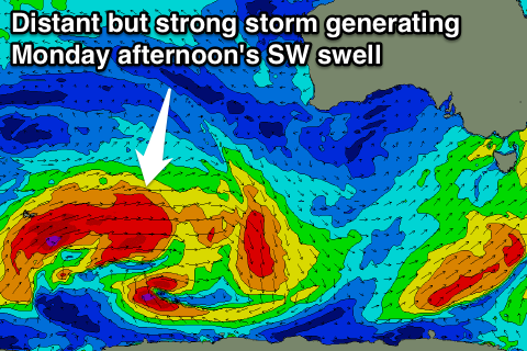
A new long-range SW groundswell is due to build through Monday, currently being generated in the Southern Indian Ocean, with inconsistent 3ft sets due at Middleton into the afternoon with 4-5ft waves at Waits and Parsons under fresh to strong NW winds. A mix of short-range W/SW swell will also be in the mix, most notable on the Mid and reaching 2ft during the day.
This W/SW swell will be related to a series of strengthening cold fronts pushing in from WA during the weekend and next week, with some larger W/SW groundswell due from Wednesday through the end of the week. We'll have a closer look at this Friday though.