Another poor week of waves ahead

South Australian Surf Forecast by Ben Matson (issued Friday 30th January)
Best Days: No great days due to regionally small swells and persistent SE winds. We once again have low confidence for a tiny line of new swell across the Mid over the weekend.
Recap: Onshore crud at Victor, tiny unrideable lines on the Mid. The Cape du Couedic buoy eventually picked up long range swell energy mid-morning Saturday (Tp 15s, easing to 13s on Sunday) but it never amounted to much surf.
Next week (Feb 3 - 6)
No change to the Victor forecast with fresh south-easterly winds expected to keep a lid on surf conditions for much of the week.
We’ll probably see light NE winds by Friday but without any new swell the damage will have been done on the surface - the best you can hope for is a few low strength peaky options about the exposed ends of the coast.
And.. with no new swell across the Mid Coast we can expect this summer flat spell to continue for some time. A tiny long range groundswell may appear at the Cape du Couedic buoy later Wednesday, with some possible tiny teasers showing on Thursday but I’m doubtful it’ll be surfable, if it shows anything at all.
This weekend (Feb 7 - 9)
Looks like we’ll see a clean window of opportunity between migrating high pressure systems on Friday and Saturday, which should allow for a period of light winds before the next onslaught of sou’easters set up camp from Sunday onwards.
So, early indications are Saturday will be your only day to surf this weekend.
As for swell, we’re not expecting much. Keen swell chart watchers will notice the period charts lighting up late Friday, suggesting a new long period swell - however this energy will be quite small in size and won’t translate to much at the coast. The reason these periods are showing so strongly is that there is simply no other swells in the water to overshadow them.
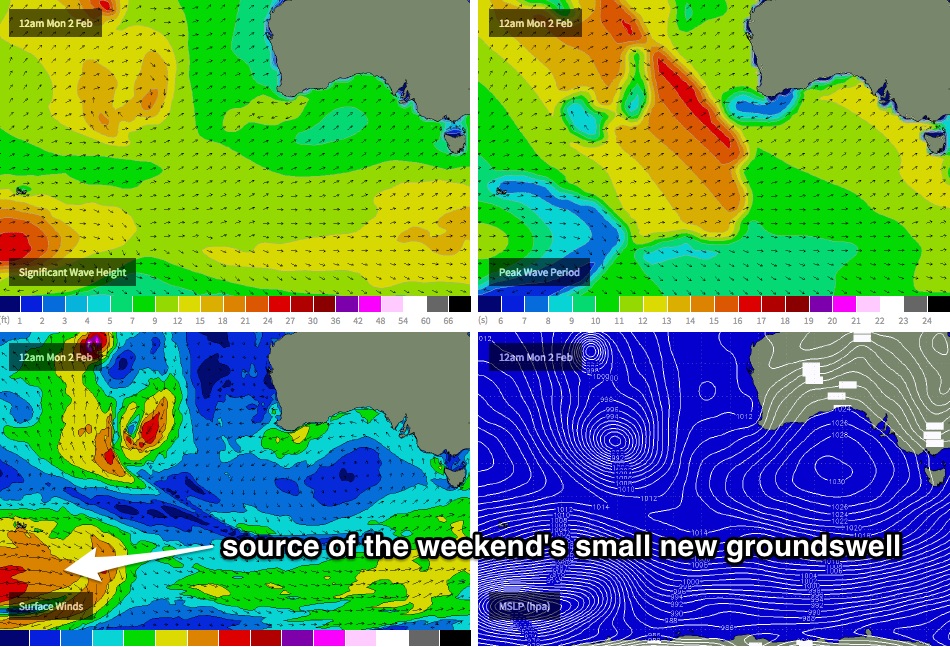
They will originate from a complex merger of several weather systems in the Southern Indian Ocean over the next few days - being Severe Tropical Cyclone Eunice, Tropical Storm Diamondra, and also a strong polar low at similar longitudes (which will essentially sweep up the two tropical systems into the low latitude westerly flow).
Of all of these systems, the polar low will probably be the best formed within our swell window (see chart below), but this will be SW of West Oz and consequently a very large distance from the Victorian coast. I think there should be just enough energy in this swell to provide a couple of small inconsistent lines across the Mid Coast throughout the weekend (perhaps 1ft+ with some tidal assistance Saturday afternoon).
At this stage, due to a reasonable level of west in the swell direction, surf size will probably remain very small at Victor, best suited to exposed ends of the coast.
I’ll have more details on this in Wednesday’s update.
Next week (Feb 10 onwards)
A stronger frontal progression behind the triple merger (mentioned above) during the second half of this week looks like generating a slightly better swell for the coast early next week. It doesn’t look like it’ll be very big but should be enough to provide a small wave on the Mid Coast (say around Tuesday). More on this on Wednesday.