Large swells from next Thursday

Nias, Mentawai, South Sumatra forecast by Craig Brokensha (issued Tuesday 18th August)
Best Days: Monday, Tuesday, Thursday week onwards
This week and next week (Aug 19 – 28)
Nothing too significant to report for the coming week with small to moderate levels of background S/SW and SW groundswell energy, largest later Wednesday and early Thursday to 3-5ft at exposed breaks around the Ments and then Saturday to 3-4ft+.
Winds will increase from the S/SE-SE from tomorrow afternoon limiting surfing options across the region.
Into next week, our stronger long-range and inconsistent S/SW groundswell is still on track. A vigorous polar low formed south of South Africa a couple of days ago and aimed a slow moving fetch of severe-gale W/SW winds through our swell window. This system is now weakening just west of Heard Island, leaving an inconsistent but strong long-period S/SW groundswell in its wake.
This swell should show later in the day Sunday and then peak Monday morning to an infrequent 5-6ft across exposed breaks before easing into the afternoon and further Tuesday and Wednesday. Winds will remain moderate to fresh from the S/SE-SE favouring protected breaks.
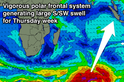 Now, as touched on the last couple of updates, some stronger groundswell energy is finally due into the end of the month and start of September with a series of vigorous polar frontal systems due to fire up through the Indian Ocean from this Friday through the following week and beyond.
An initial strengthening polar frontal system south-east of South Africa this Friday will project a fetch of gale to severe-gale W/SW winds through our southern swell window while tracking towards Australia.
A large long-period S/SW groundswell should be generated, filling in Thursday and peaking through the day to 6-8ft across exposed breaks. This swell will then ease into Friday, with a smaller reinforcing S/SW swell for the weekend, building later Saturday and peaking Sunday to the 6ft+ range across exposed breaks. Winds will also improve tending more E'ly Saturday and then variable Sunday.
Longer term we may see a stronger S/SW groundswell compared to Thursday's filling in Tuesday the 1st of September but we'll confirm this on Thursday.
16 day Mentawai forecast graph
16 day Nias forecast graph
16 day South Sumatra forecast graph