Indonesia/Maldives forecast Jun 5

Indian Ocean Basin analysis by Craig Brokensha (issued Thursday 5th June)
This week through next (Jun 6 - 13)
Large surf should have filled in across the regions yesterday with the arrival of a strong SW groundswell, still large today and more south in nature with a drop in period.
This easing trend will continue slowly tomorrow ahead of the first in a series of long-range SW groundswells through the weekend.

There’s been no change to the sizes or timings, with an initial, moderate sized SW groundswell expected to build Saturday, holding Sunday morning across the region, with a secondary larger and better swell due into Sunday afternoon/Monday morning
Both were generated by strong systems forming under South Africa, with the first for Saturday being a tight, intense low, with Sunday/Monday’s swell generated by a much more robust frontal progression pushing under the country.
We’re then expected to see a third reinforcing SW groundswell for later Monday but more so Tuesday morning, produced by a trailing polar low in the wake of the frontal progression moving under South Africa, forming a little more east but with less strength.
As a result the reinforcing swell looks to come in a little under the size due Sunday afternoon/Monday morning.

Looking at the middle of next week’s large SW groundswell and interestingly GFS won the battle of the models (downgrade), with EC going for a stronger swell generating front through the Indian Ocean, but alas the system looks short-lived and patchy.
We’re still expected to see a healthy fetch of W/SW gales firing up to the south-east of Madagascar today and tomorrow, with a moderate + sized SW groundswell due for the Mentawais, more so moderate in size for Bali, arriving overnight Tuesday and peaking Wednesday.
Luckily, a secondary intensification on the backside of the progression to the north-east of Heard Island should produce a tight but good fetch of gale to severe-gale W/SW winds in our southern swell window.
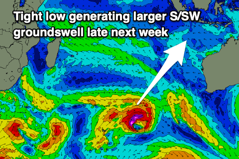
This should produce a larger S/SW groundswell for later week, building later Thursday and peaking Friday morning.
Longer term, a broad, strong polar frontal progression forming west of the Heard Island region this Sunday should produce a good, moderate to large sized SW groundswell for the week starting the 16th of June. More on this next Tuesday though.
Looking at the local winds, and freshening SE trades will strengthen further into next week while tending E/SE, strongest through the middle to end of the week before possibly slowly abating next weekend.
Over in the Mentawais our variable winds are still on the cards, apart from some W/NW-NW surges across northern regions this Sunday/Monday and then increasing SE trades across southern regions later next week.
----------------------------------------------
Maldives:
A good, solid mix of S/SE trade-swell and S/SE groundswell that’s currently breaking across the region should ease a little into tomorrow, though the trade-swell will remain solid thanks to a robust fetch of SE trades currently sitting south of the region.

This will weaken tomorrow and break down further through the weekend resulting in easing levels of S/SE swell from Saturday.
Now, in saying this, a new and stronger fetch of SE trades will start to develop directly south of the region through Sunday/Monday, weakening a little into Tuesday while a more distant fetch of SE trades sets up to our south-east.
What this will do is produce a moderate + sized pulse of mid-period S’ly swell for Wednesday afternoon/Thursday, easing into the end of the week, with some less consistent, smaller SE swell to follow from the following weekend.
Southerly groundswell wise and the activity south of South Africa will produce decent sized sets from tomorrow through Monday, while the fetch forming south-east of Madagascar will produce a stronger increase in size later in the day Monday and Tuesday morning.
Local winds are still expected to shift more W’ly and freshen over the weekend, stronger W/SW-SW early next week with the southern atolls seeing slightly weaker winds, tending more SW mid-late next week.
Eastern Indonesia:
Slowly easing mid-period S/SW swell over the coming days
Moderate sized, inconsistent SW groundswell building Saturday, peaking into the afternoon and Sunday morning to 4-5ft+.
Larger, inconsistent SW groundswell for Sunday afternoon more to 6ft+ across exposed breaks, similar Monday morning.
Easing trend slowed by a reinforcing SW groundswell Tuesday.
Moderate + sized, SW groundswell Wednesday to 4-6ft across exposed breaks.
Larger S/SW groundswell for later Thursday, peaking Friday morning to 6ft to occasionally 8ft across exposed breaks.
Freshening SE trades over the coming days, stronger into next week from the E/SE (variable offshore each morning).
Uluwatu 16-day Forecast Graph/WAMs
Western Indonesia/Mentawais/South Sumatra:
Moderate to large, inconsistent SW groundswell for later tomorrow but more so Saturday to 4-6ft.
Larger, SW groundswell, peaking Sunday to 6ft to occasionally 8ft across exposed breaks, easing slowly Monday, slowed by a reinforcing pulse into the afternoon.
Moderate to large sized SW groundswell Wednesday to 6ft+ across exposed breaks.
Moderate to large S’ly groundswell for later Thursday but more so Friday to 5-6ft across exposed breaks.
Variable winds this period, likely fresh at times from the W/NW-NW across northern locations Sunday/Monday, possibly freshening from the SE across southern locations late next week.
Mentawai 16-day Forecast Graph/WAMs
Maldives:
Moderate sized mid-period S/SE swell to 3-5ft across central locations tomorrow, bigger and to 4-5ft+ across the southern atolls.
Slowly easing S/SE trade-swell on the weekend and early next week.
Moderate to large sized mid-period S’ly swell for later Wednesday and Thursday morning to 6ft across the southern atolls, 3-5ft central locations.
Inconsistent moderate sized S/SW groundswell from Friday through early next week to 5ft on the southern atolls.
Larger S/SW groundswell likely later Monday and Tuesday morning to 5-6ft on the southern atolls.
Freshening W’ly winds over the coming days stronger W/SW-SW next week (weaker to the south).
Comments
Latest notes are live.
Any chance for a Telos Island forecast from the 16th June? Thanks