Indonesia/Maldives forecast February 22

Indian Ocean Basin analysis by Craig Brokensha (issued Thursday 22nd February)
This week through next (Feb 23 - Mar 1)
Small background levels of swell are padding out the exposed breaks, while we should start to see some better mid-period S/SW swell energy arriving through the weekend but the middle of next week looks best.
The mid-period energy for later Saturday but more so Sunday was generated by a healthy but weakening polar front projecting up into the Indian Ocean earlier in the week.
This should provide a fairly consistent pulse of swell, peaking Sunday and then easing Monday and further Tuesday morning.
For the rest of the week, a small mix of weak S’ly swell and background mid-period energy look to hold in the 4ft range across the magnets, with the next more noticeable increase in energy due late week.
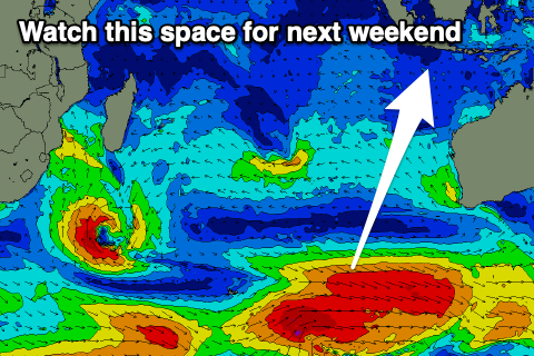
This will be generated by a broad, healthy frontal progression that’s currently south-west of Western Australia, with an initial fetch of W/SW winds due to be followed by stronger W/NW winds on top of the active sea state Saturday.
The swell is due to fill in next Friday, building to 4-5ft across exposed breaks before easing Saturday.
Following this some more significant frontal activity looks to generate some larger surf from Sunday week but we'll review this next Tuesday.
Across to the Maldives and NE windswell has been replaced by some better mid-period S’ly swell today which is due to ease into tomorrow. It should be backed up by some slightly strong S’ly swell on Saturday (generated by the polar front pushing north through the Indian Ocean) with a bit more energy to the sets, peaking through the afternoon before easing Sunday.
Following this, small levels of S/SE swell are due into next week from a weak fetch of S/SE winds in the Indian Ocean, but no major size is due. Therefore make the most of the current and coming S’ly swell.
Eastern Indonesia:
Moderate sized, mid-period S/SW swell building late Saturday, peaking Sunday to 4-5ft, easing Monday.
Background S-S/SW swells for most of next week to 4ft across exposed breaks.
Inconsistent, mid-period S/SW swell filling in next Friday, reaching 4-5ft across exposed breaks,.
Larger, reinforcing S/SW groundswell likely Sunday (3rd).
NW winds tomorrow, Saturday and Sunday morning with weak afternoon W/SW winds from Sunday afternoon through Monday and Tuesday. More variable winds from mid-week, possibly fresher W/NW the following weekend.
Uluwatu 16-day Forecast Graph/WAMs
Western Indonesia/Mentawais/South Sumatra:
Small, mid-period W/SW swell today to 3ft+ across exposed coasts, easing into tomorrow and the weekend.
Moderate sized, mid-period S/SW swell building Saturday, peaking Sunday to 4-5ft, easing Monday.
Mixed S’ly swells for the rest of next week to 4ft across exposed breaks.
Moderate-large sized S’ly groundswell for Sunday (2nd) to 4-6ft.
Variable winds, tending E/SE-SE next week, then possible NW the following weekend.
Mentawai 16-day Forecast Graph/WAMs
Maldives:
Moderate sized mid-period S’ly swell easing today from 3-4ft on the southern atolls, smaller and to 3ft tomorrow.
Good mid-period S’ly swell Saturday, reaching 3-5ft into the afternoon, easing from 4ft Sunday morning.
Smaller S/SE swell next week.
Moderate E/NE winds tomorrow and Saturday, tending N/NE Sunday, holding Monday before freshening from the E/NE Tuesday and Wednesday.
Comments
Latest notes are live.