Indonesia/Maldives forecast October 10th

Indian Ocean Basin analysis by Craig Brokensha (issued Tuesday 10th October)
This week through next week (Oct 11 - 20)
The surf is easing across the Indonesian region, though a small, background SW groundswell is due to arrive later today, peaking tomorrow though to no major size. The magnets should be fun though inconsistent and not to the size shown on the models as they're incorrectly combining swells.
Into the end of the week, a fun pulse of mid-period S/SW swell is due, generated by a small, tight, slow moving low that formed to the south-west of Western Australia on Sunday. A fetch of slow moving strong to at times gale-force winds have generated a fun, moderate sized + swell that should build Friday, peaking later and then easing Saturday.
Following this, our long-range SW groundswell which was discussed last Thursday is on track, with a broad but relatively weak low forming to the south-east of South Africa.
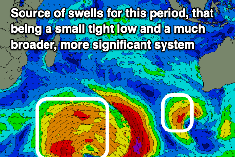
A significant fetch of severe-gale N/NW winds have been generated at the head of the low, aimed towards the polar shelf, while trailing strong W/SW winds are due to strengthen today on the polar shelf, generating an additional gale to severe-gale fetch of W'ly winds.
What will result is a small pulse of inconsistent groundswell from the N/NW fetch Sunday, ahead of a moderate + sized SW groundswell Monday, peaking into the afternoon.
Following this there's nothing too major on the cards for the region. A small mid-period swell may be seen next weekend but to no major strength. Lighter trades are due over the coming period with favourable conditions across the magnets each morning thanks to local sea breezes.
For the Maldives, SE trade-swell energy continued to to ease across the region with a low point in energy seen yesterday. The swell should muscle up a touch this afternoon and further tomorrow thanks to a burst of E/SE trades through the Indian Ocean. It'll be a brief pulse with easing surf again due into the end of the week and next week thanks to slowly retreating trades.
S'ly groundswell will become more dominant, with the current background energy due to be replaced by a stronger pulse of energy from the low that formed to the south-east of South Africa.
This should arrive Friday and peak into the afternoon followed by a secondary, larger pulse on Saturday, then easing into Sunday and Monday.
This makes the coming week and weekend the most active for surf with next week being much slower.
Eastern Indonesia:
Small, background SW groundswell arriving later today, peaking tomorrow to an inconsistent 4ft across the magnets.
Moderate + sized mid-period S/SW swell building Friday, reaching 6ft into the afternoon, easing Saturday from 5-6ft.
Moderate sized, inconsistent SW groundswell building Sunday, peaking Monday (16th) to 6ft on the magnets into the afternoon, easing Tuesday
Weak, moderate to fresh E/SE-SE trades, light and variable each morning.
Uluwatu 16-day Forecast Graph/WAMs
Western Indonesia/Mentawais/South Sumatra:
Small to moderate sized, background SW groundswell arriving this afternoon, peaking tomorrow to 3-5ft across exposed breaks.
Moderate sized, mid-period S'ly swell for Friday to 4-5ft across exposed breaks, easing into the weekend.
Moderate + sized, inconsistent SW groundswell building Sunday (15th), peaking Monday morning to 6ft across exposed breaks. Easing surf thereafter for the remainder of the week.
Fresh SE-S/SE trades across southern locations, lighter and more variable to the north though having a S-SE tendency.
Mentawai 16-day Forecast Graph/WAMs
Maldives:
Building SE trade-swell this afternoon, peaking tomorrow to 4ft+ across the southern atolls (smaller Male).
Slowly easing SE trade-swell from Thursday into the weekend (though not below 3ft). Swell easing more so into later next week.
Moderate sized S'ly groundswell building Friday, peaking Saturday to 5-6ft across the southern atolls (smaller Male).
Slowly easing swell Sunday and into early next week.
Variable winds across the northern and central locations for the coming days (fresh E/SE to the south). Winds tending S/SE-SE later week and persisting this weekend across northern and central locations (E/SE to the south).
Comments
Latest notes are live.