Indonesia/Maldives forecast September 26th

Indian Ocean Basin analysis by Craig Brokensha (issued Tuesday 26th September)
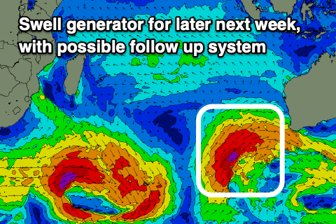
This week through next week (Sep 27 – Oct 6)
The large, inconsistent long-period SW groundswell seen through the weekend slowly eased off through yesterday and is continuing to ease through today across all locations.
Some reinforcing mid-period S/SW swell should stop the easing trend this afternoon and hold tomorrow, with moderate sized + surf persisting tomorrow, easing slowly Thursday.

The next pulse of groundswell is due on Friday (peaking into the afternoon), generated by a healthy but short-lived frontal system that fired up north-east of the Heard Island region Sunday evening. A fetch of gale to severe-gale W/NW winds have generated another moderate + sized pulse of S/SW groundswell for late week, easing into the weekend.
Following this there's nothing too major on the cards for early to mid-next week with background pulses of moderate + sized mid-period swell due to pad out exposed breaks ahead of a larger swell late week.
The source of this larger groundswell will be a strong, slow moving polar frontal progression forming around the Heard Island region this weekend, projecting up and across Western Australia early next week.
The models are still moving around regarding the structure of the progression with EC having it more as one, consolidated push north-east while GFS breaks it into a couple of incursions but overall we can expect a large S/SW groundswell to arrive through Wednesday afternoon next week, likely peaking Thursday.
Follow up but smaller pulses are likely through the following week, but we'll review this on Thursday.
Local winds will be influenced by the positive (+) Indian Ocean Dipole event across western Java, Sumatra and the Mentawais with persistent, unfavourable S/SE-SE trades.
Looking west towards the Maldives and we've got easing levels of SE trade-swell thanks to weak trades throughout the Indian Ocean.
The surf will remain on the smaller side of the coin out of the SE until Sunday/Monday when we should see a renewal of moderate + sized energy thanks to a strengthening of the trades late this week and more so through the weekend.
S'ly groundswell wise, we're seeing some fun background energy currently and this will persist through most of the period, with a couple of stronger pulses due Thursday, but more so mid-late next week.
Next week's swells will be generated by the frontal progression firing up around the Heard Island region, but well have a closer look at the details surrounding this on Thursday when the models should be more in alignment.
Eastern Indonesia:
Moderate sized + background S/SW swell energy to 5-6ft across exposed breaks tomorrow, easing slowly Thursday.
Moderate + sized S/SW groundswell for Friday, peaking into the afternoon to 6ft+ across exposed breaks, easing through Saturday and further Sunday.
Moderate, mid-period background S/SW swells for early next week to 4-6ft mostly later Monday and Tuesday, easing Wednesday.
Large S/SW groundswell building Wednesday afternoon, peaking Thursday to the 8-10ft range across exposed breaks.
Weak E/SE-SE trades, light and variable each morning. Similar strength trades shifting a little more SE-S/SE next week.
Uluwatu 16-day Forecast Graph/WAMs
Western Indonesia/Mentawais/South Sumatra:
Moderate sized mid-period S/SW swell building today, easing tomorrow from 4-5ft across exposed breaks, smaller Thursday.
Moderate sized + S/SW groundswell building Friday and peaking into the afternoon to 6ft across exposed breaks, easing Saturday.
Reinforcing mid-period S/SW swell for Sunday/Monday to 4-5ft+.
Large S/SW groundswell building Wednesday afternoon, peaking Thursday to 8ft+ across exposed breaks, easing Friday.
Fresh to strong SE-S/SE trades across southern locations, fresh to the north.
Mentawai 16-day Forecast Graph/WAMs
Maldives:
Easing SE trade-swell over the coming days from 4ft across the southern atolls today, not getting below 3ft. Slightly smaller Male.
Inconsistent S'ly groundswell for the coming days to 3ft+ across the southern atolls, smaller Male.
Moderate sized + SE trade-swell building Saturday afternoon, peaking Sunday/Monday to 4-6ft across the southern atolls, slightly smaller Male.
Moderate sized S'ly groundswell for mid-late next week to 4-5ft across the southern atolls.
Slowly strengthen W/SW-SW winds across northern to central atolls, weaker S/SE to the south.
Winds shifting S/SW across northern to central locations on the weekend, S/SE-SE to the south.
Comments
Latest notes are live.
Thanks doing another Indo forecast ! Hoping you can update later this week or early next week for next week's swell - yeeew