Indonesia/Maldives forecast August 3rd

Indian Ocean Basin analysis by Craig Brokensha (issued Thursday 3rd August)
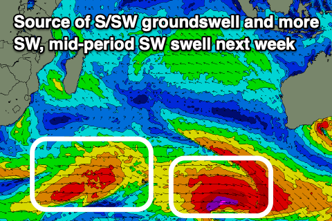
This week through next week (Aug 4 - 11)
The large reinforcing pulse of swell for Thursday afternoon was reported as strong across the region yesterday, with it now easing ahead of our larger, long-period S/SW groundswell through tomorrow.

As touched on in Tuesday's update, the source was a strong but tight (regarding the strongest swell generating winds) low that developed between the Heard Island region and Western Australia. There were a few things I liked about this low and a few that I disliked.
The positives are the south to north alignment and storm-force core fetch aimed towards Indonesia, but the tight nature, eastward track and southerly direction mean there'll be a wide range of sizes.
The swell is due to fill in tomorrow and building strongly mid-late afternoon, reaching a peak into the evening before easing Saturday while going a little more south in direction.
I'll be even more south across western Indonesia and arrive from the S/SE in the Maldives, building tomorrow and then easing Saturday.
The size will continue to trend down into Sunday and Monday ahead of a new, moderate-large pulse of S/SW groundswell Tuesday and reinforcing mid-period swell for Wednesday.
The groundswell is being generated by a strong polar that's formed east of the Heard Island region, in eastern Indonesia's south swell window. A fetch of W'ly gales should produce a fun sized but slightly inconsistent S/SW groundswell for Tuesday, peaking through the afternoon. The swell will be smaller in Western Indonesia.
A secondary broader and more northerly tracking front will produce strong to sub-gale-force W/SW winds though over a longer period, producing a lower period but slightly larger pulse of SW swell for Wednesday. The surf should then slowly ease into the end of the week.
The Maldives will see the second mid-period S'ly swell but not the first S'ly groundswell, with it arriving Sunday afternoon, peaking overnight, easing Monday.
The strong pulse of SE trade-swell is also due into tomorrow, building through the day and peaking Saturday before easing slowly Sunday and into next week, becoming small to moderate in size later week.
Eastern Indonesia:
Large spike of S/SW groundswell building Friday, reaching 10ft across exposed breaks late, easing from a similar size Saturday morning. Magnets likely to see some bigger cleanups at the peak of the swell.
Inconsistent S/SW groundswell building Tuesday, reaching 6ft into the afternoon across exposed breaks with a reinforcing pulse of mid-period SW swell to 6ft to occasionally 8ft Wednesday, easing slowly through the end of the week.
Moderate to fresh E/SE-SE trades for the coming days, light and variable each morning. Moderate to fresh SE trades next week, light and variable each morning. Weaker later next week.
Uluwatu 16-day Forecast Graph/WAMs
Western Indonesia/Mentawais/South Sumatra:
Large S'ly groundswell building late Friday, peaking Saturday to 10ft across exposed south facing breaks.
Moderate to large mix of mid-period and S/SW groundswell for Tuesday afternoon through Thursday to 6ft+ across exposed breaks.
Fresh to strong S/SE-SE winds tomorrow across southern locations, lighter and more variable to the north. Similar Saturday, weakening across the south through Sunday
Moderate E/SE tending variable winds across southern locations Monday, variable to the north.
Freshening SE winds across southern locations from Tuesday, persisting the rest of the week but light and variable to the north.
Mentawai 16-day Forecast Graph/WAMs
Maldives:
New episode of moderate sized + SE trade-swell building tomorrow, peaking Saturday to 6ft across southern locations (a touch smaller Male).
Smaller S/SE groundswell in the mix building tomorrow, easing Saturday.
Slowly easing SE trade-swell Sunday and into next week, levelling out around 3-4ft later week.
Moderate sized mix of S'ly swells building Sunday afternoon to 4ft, easing Monday from a similar range across the southern atolls (smaller Male).
Persistent W'ly winds across northern and central locations, tending W/NW on the weekend and Monday, back to the W on Tuesday. W/NW-NW mid-late week.
Weak S/SE-SE winds across southern regions tomorrow, more variable on the weekend and next week.
Comments
Latest notes are live.
Wow
What’s the bet it dies in the arse last week of August
Hey Craig, love your work mate! - heading to Ekas on Lombok 8-15th. How much size do I shave off the Ulu forecast for that area? Winds looks great though!
Maldives pumping now, likely day of the season Sunday 6th. https://www.perfectwavetravel.com/magazine/maldives/maldives-surf-report...