Large windy swell to end the week, good swells developing next week, large across P-Pass

Hawaii North Shore, Micronesia and PNG forecast by Craig Brokensha (issued on Thursday 27th December)
Best days: North Shore tomorrow, later Friday and more so Saturday, Tuesday afternoon onwards - Micronesia tomorrow morning, Tuesday onwards
This week and next (Dec 14 - 21)
Hawaii: Our better NW groundswell for today has filled in across the island with 6ft+ sets on the magnets with great conditions.
This swell will ease back temporarily through tomorrow from the 4-5ft range with light E/SE winds, while on dark we may see the long-period forerunners of our larger swell for Friday filling in.
The swell was produced by a distant but significant storm spawning off Japan earlier this week, with a fetch of severe-gale to storm-force W/NW winds projected through our north-western swell window.
The low stalled slightly while weakening and is now breaking down south of the Aleutian Islands. With this we'll see the easing trend slowed a little.
The bulk of the swell is due to fill in Friday with inconsistent 8-10ft+ sets developing across the marquee reefs into the afternoon but a trough moving in from the west will bring average N/NE winds, improving later and tending more NE.
Saturday looks much better with E/NE trades and easing surf from 6-8ft, smaller Sunday.
The coast will remain quiet until about Tuesday when we see some inconsistent new long-period NW groundswell, growing further in strength Wednesday ahead of a larger W/NW groundswell Thursday.
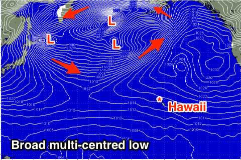 These swells will be produced by a broad and multi-centred storm forming across Japan, the Kamchatka Peninsula and the Aleutian Islands.
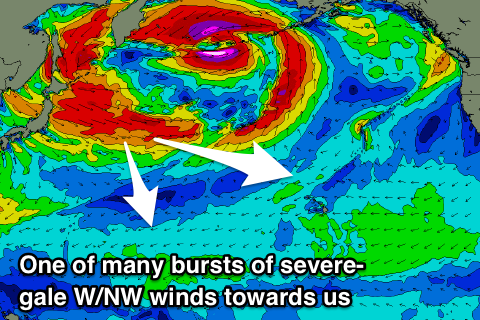
Bursts of broader and stronger severe-gale W/NW winds will be projected through our north-western swell window, generating building pulses of NW groundswell, while a more southerly fetch of severe-gale W/NW winds projecting towards us will generate the largest W/NW pulse.
A gradual increase in size is expected from Tuesday, increasing from 3-4ft in the morning upwards to 6ft+ late in the day with a bigger pulse Wednesday to 6-8ft+ through the day, with Thursday's W/NW swell seeing a bit of variation in size but coming in at 10ft across the marquee reefs.
Winds are looking great with gusty but favourable E-E/NE trades, strongest as the swell peaks on Thursday. More on this in the next update though.
North Shore Forecast Graph
North Shore WAMs
 Micronesia: We should be seeing a fun pulse of N'ly groundswell breaking across our north facing reef passes with sets to 3-5ft, easing into this afternoon.
This swell will back off tomorrow from 3ft+ on the sets, smaller into Saturday.
We've then got some great and large pulses of N'ly groundswell due from Tuesday next week as the broad multi-centred storm off Japan is perfectly positioned in our swell window.
Also the more southerly fetch will generate a large and significant groundswell for Thursday.
Our first pulse of swell for Tuesday looks to come in at 4-5ft, building a little more into the afternoon with larger 6ft+ sets on Wednesday and then Thursday will be very solid and in the 8-10ft range on the sets.
Strong NE tending E/NE trades are expected through this period adding some tricky trade-swell to the mix, with weaker winds as the swell easing into Friday and the weekend.
Palikir Pass Forecast Graph
Palikir Pass WAMs
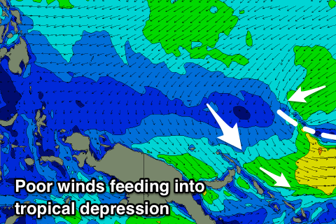 Papua New Guinea: We've currently got poor W/NW winds across the region owing to strengthening tropical activity associated with an active phase of the Madden Julian Oscillation.
We're likely to see a deepening tropical low to our east which will swing winds less favourable and around to the NW through the weekend and persist all of next week as it stalls.
This will unfortunately spoil building levels of NE trade-swell, but also the N'ly groundswell that's due to arrive through the middle of the week and peak next Friday/Saturday to 4-6ft across north swell magnets. Options for a good wave will be severely limited.
Comments
Latest Hawaii, Micronesia (looking large) and PNG forecast here.
Hi Craig
I’ve got a week in PNG (Tupira) booked from Saturday - it’s not looking good! Do you know whether the forecast NW winds will be bad for Tupira and the Madang region? Seems like these will be cross-shore, but very strong. I’m trying to decide whether to actually bother going. If it’s a windy mess for a week it will be no fun. Do you know anything about the specifics of this region and the forecast conditions? Thanks
Is your PNG forecast principally tailored for the Kavieng region?
Hey mate, yeah it is tailored for Kavieng. I'm not familiar and sure of the options around the region you're heading to, but looking closer at the local winds and it looks like there'll be a handful of mornings with local lighter W/SW-SW winds, creating cleaner conditions. So it doesn't look a total write-off, but yeah sorry I can't help more.
Thanks for the reply Craig. I really appreciate the extra info. Sounds like there’s still a possibility of a cleanish wave. Cheers
No worries, good luck!
great to see some northern hemi analysis thanks Craig!!!
your fcst been spot on for last two N swells here in Sols, even when i got cold feet last swell cos the fetch pointed more east than south and period shorter than usual, I trusted your model and the 300km roundtrip in small boat gamble paid off, sure enough it pumped!
Next week's looks like N swell of the season for these parts but as you mentioned EC, GFS, BOM all calling for gnarly TD/TC activity coinciding with arrival of that swell. not small boat crossing weather or clean waves so looks like just have to hunker down here on the south side and hope for some short period stuff tucked out of the westerlies, wrapping in off the TC as it goes past.
heres hoping that amongst all the north and south hemi mocean here nxt week we get some barrels worthy of this new 6’8 Desert Storm Webby shaped me
recently bailed Surfline sub after fifteen years for Swellnet, no regrets! one thing i do miss tho is their directed fetch charts with the great circle target overlay, essential for assessing blocking from various island chains in Micro as well as OJ that the models dont see. have tried using Windy [with Google Earth's measure tool for great circle] but neither EC or GFS seem to agree with your model output. any options? the other query is access to archival data for hindcasting, key tool in working out what directions and periods manage to make it thru the Micronesia screen, would much rather pay you guys than Buoyweather, any options there?
While i'm at it, one thing that would improve your Sols forecasts, for the north-facing Choiseul North East [which is used also for north Isabel where the surf camps are = more users] be cool if can remove south sector data from 100 deg thru 300 as it is physically impossible for that swell to reach that coast.
Same goes for your three New Georgia and the Ranongga location forecasts - remove north sector data from 320 deg thru 110 deg as north swell does not make it thru the Bougainville/Choiseul/Isabel chain.
keep up the great work guys!
Thanks for the feedback, that's really useful information mate.
Without going into too much detail, we're working on a brand new forecast portal that'll be launched mid-2019, that contains a lot of the stuff you mentioned (plus more products). A lot of these new ideas have been sitting around waiting to be built for many, many years, some of which are not available elsewhere too so we're very confident they'll be very useful for these kinds of intricate planning missions.
We're also upgrading our location directory and will cover the SPac region with a more granular offering of location points. However good bathy data for the region doesn't really exist and there's some really complex trenches that funnel long period swells in all kinds of unusual ways, which the models will never be able to accurately resolve.
Anyway, thanks again for the feedback - we're stoked it's performing well for you.
Yeah thanks Kavachi, Ben's covered most of the above in his post but it's always great to get on the ground feedback to help fine tune the output and data. Have a great New Year!