Large N'ly swells for the North Shore, stormy W/NW surf next week

Hawaii North Shore forecast by Craig Brokensha (issued Tuesday 31st January)
Best Days: North Shore north swell friendly breaks for experienced surfers the coming days, spots that handle SW winds from the weekend
This week and next (Feb 1 - 10)
Hawaii: Currently an XL NW tending N/NW groundswell is easing across the North Shore along with fresh NE winds.
 The swell will continue to drop off through tomorrow from a more N'th angle, easing from the 8-10ft range, smaller into the afternoon.
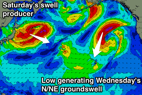
Our reinforcing N/NE groundswell for the afternoon and more so Wednesday is on track, with the remnants of the low generating today's swell, stalling to our north today, aiming a fetch of gale to severe-gale N/NE winds through our northern swell window.
This will produce a large mid-period N/NE groundswell, peaking through Wednesday around the 8-10ft range (bigger more exposed breaks), easing back slow from Thursday, more noticeably into the afternoon and Friday.
E/NE trades will create clean conditions tomorrow, weaker Wednesday and then more variable Thursday ahead of a weak SW'ly Friday.
Into Saturday a new long-range NW groundswell is due across the islands, with it currently being produced by a deep low forming east of Japan.
We'll see a vast fetch of gale to severe-gale NW winds aimed at us, producing a large NW groundswell coming in around 6-8ft across the North Shore, easing into Sunday.
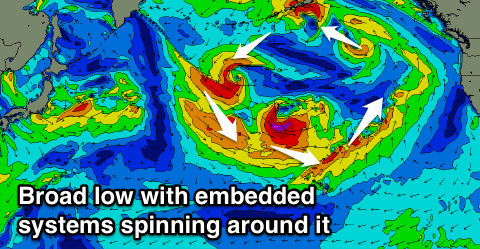 Winds however look to take a turn for the worst with SW Konas Saturday, strengthening Sunday and reaching near gale-force range Monday and Tuesday as a large complex low sets up to our north.
This broad low will have a series of embedded fronts, pushing into and across Hawaii from early next week through late week, generating raw XL W/NW swells Tuesday and Wednesday.
We'll see the low break down late week resulting in improving winds and easing swells, but more on this Thursday.
North Shore Forecast Graph
North Shore WAMs
Micronesia: Our run of N/NW groundswell is finally on the way out with small levels of weak E/NE trade-swell keeping exposed breaks active, but with gusty onshore E/NE winds.
The low generating Hawaii's swell this Saturday should also produce a fun increase in N/NW groundswell for us Saturday to 3-4ft+, holding Sunday ahead of a larger increase Monday from a secondary more southerly low spawning off Japan.
This secondary swell looks to come in around 4-6ft Monday before easing off slowly into the rest of the week, owing to its persistent nature. Trades should ease off a little this weekend and possibly again the middle of next week.
Palikir Pass Forecast Graph
Palikir Pass WAMs
Papua New Guinea: Our current mix of E/NE trade-swell and inconsistent N'ly groundswell will slowly ease over the coming days, with small surf due into the start of the weekend.
The new N'ly groundswell energy is due to build Sunday, reaching 3ft on the sets, holding Monday with the slightly larger pulse Tuesday to 4ft or so. Winds are looking variable for the most part creating good conditions.