Easing XL swell ahead of a larger XL swell next week

Hawaii North Shore forecast by Craig Brokensha (issued Thursday 19th January)
Best Days: Experienced surfers Hawaii tomorrow and Friday morning, again from later Wednesday, Micronesia and PNG the whole period
This week and next (Jan 19 - 27)
Hawaii: Currently an XL swell is building across the North Shore, with the 51101 buoy north-west of Hawaii rising sharply in size to 16-19ft at 16s.
This swell is starting to show on the North Shore, a little later than expected, but we should still see XL waves around 12-15ft tomorrow morning, easing steadily through the afternoon.
The reinforcing W/NW groundswell for Friday should see wave heights hanging around 8ft all day, easing off steadily through Saturday and Sunday.
Winds are due to be great tomorrow with moderate to fresh E'ly trades, lighter Friday morning before increasing from the N/NE.
The NE swell due Saturday afternoon and Sunday morning is still on the cards but the size looks to be limited to 4-5ft across magnets, easing into Sunday afternoon as it swings more east in direction.
This will be produced by a fetch of NE winds projecting towards us as a strong high ridges with a low forming to our north-east.
 Along with this will come strong and poor NE winds Saturday, more E/NE Sunday and easing in strength.
Come Monday there's no decent swell due to be left over and winds are due to tend variable.
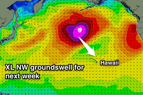
Our secondary XL swell event for next week is still on track, but the direction will be mainly from the NW.
A very intense low spawning off Japan will generate a burst of severe-gale to storm-force W/NW winds in our far western swell window. The low is expected to track east while slightly weakening before re-intensifying to our north-west.
A broader fetch of severe-gale to storm-force W/NW winds should be aimed through our swell window from Sunday morning through Tuesday morning, producing an XL NW groundswell event.
We should see this swell arriving Wednesday and building rapidly to 15ft+ later Tuesday, peaking Wednesday morning around 15-20ft. A slow easing trend is then due into the afternoon and further Thursday.
Winds on Tuesday as the swell builds will be average with a N/NE tending NE breeze, while fresh E/NE trades are expected Wednesday, easing into Thursday.
Longer term another XL swell may be seen Sunday week, but more on this Tuesday.
North Shore Forecast Graph
North Shore WAMs
Micronesia: Yesterday's large N/NW groundswell is currently easing, but our reinforcing pulse for tomorrow is still on track.
Exposed breaks are due to build back to 4-6ft through the day tomorrow, easing off Saturday and further Sunday.
The vigorous low spawning off Japan will deliver another large N/NW groundswell for Tuesday/Wednesday.
A strong kick is due Tuesday afternoon, reaching 5-6ft on the sets later in the day, easing off from 4-6ft Wednesday and further Thursday.
Fresh and gusty E/NE trades are expected over the coming period, possibly easing a little later next week.
Also in the mix over the coming period will be moderate levels of E/NE trade-swell from a strong and stationary fetch of E/NE trades directly east of Micronesia, easing a little over the weekend but persisting all off next week. Spots picking up this swell will be poor in any case.
Palikir Pass Forecast Graph
Palikir Pass WAMs
Papua New Guinea: This morning's good pulse of N/NW groundswell should ease off further into tomorrow, only to be replaced by a new swell over the weekend.
Open reeds to the north are due to reach 3-4ft by Saturday afternoon, holding Sunday before easing Monday. This is then some new NE trade-swell should take over, coming in around a similar size through all of next week.
The inconsistent N/NW groundswell impacting Micronesia Tuesday/Wednesday is then due to arrive Wednesday afternoon to an inconsistent 3ft or so.
Light variable winds the coming days are now due to increase a little from the west during the middle of next week, easing into the following weekend.
Comments
That north swell doing its thang in Micronesia..