Average run of swell, hopefully better late next week

Hawaii North Shore forecast by Craig Brokensha (issued Thursday 8th December)
Best Days: North Shore tomorrow, Tuesday morning, later next week onwards, Micronesia next Friday
This week and next (Dec 9 - 16)
Hawaii: A new inconsistent NW groundswell is building across the North Shore, with 3-5ft sets through this morning, and a further increase to a peak this afternoon at 5-6ft is due.
 This swell should ease off through tomorrow, from 4-5ft at swell magnets early as a variable tending S'ly wind develops.
Come Friday there's nothing of significance due at all and winds should ease off into the weekend.
The lack of swell is due to an upper level blocking pattern, with the storm track not favourably aligned for us at all.
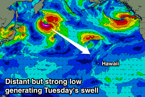
Into early next week a small and inconsistent NW groundswell is due, generated by a small but intense low forming south-east of the Kamchatka Peninsula over the coming days.
A tight fetch of severe-gale to storm-force winds will be generated, with the groundswell due to arrive through Monday afternoon, peaking Tuesday morning around a very inconsistent 4-5ft.
Gusty NE trades are due to develop on Tuesday creating less than ideal conditions, with easing surf and E/NE winds Wednesday.
A small N'ly swell is expected Wednesday from a weakening cut-off low to our north, with no major size due from this system. Swell magnets exposed to the north may see 3-4ft sets Wednesday afternoon and Thursday morning.
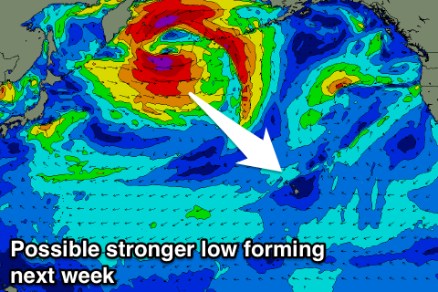 Longer term we may see a stronger storm develop off Japan and try to push towards us early next week before being deflected back to the north by a blocking high south of the Aleutians.
A fetch of W/NW gales will initially be aimed towards us, while as the front is deflected to the north, it will deepen into a more significant low, producing an additional fetch of severe-gale W/NW winds through our far swell window.
What should result is an inconsistent NW groundswell for Friday morning followed closely behind by a larger increase in size through the afternoon from the low.
4-5ft sets are likely Friday morning, building through the afternoon, and then peaking Saturday. We'll take a closer look at this Tuesday though.
North Shore Forecast Graph
North Shore WAMs
Micronesia: Our recent north-east trade-swell event is on the way out, with the trades weakening through the Central Pacific Ocean resulting in a downwards trend in size from today.
Exposed breaks should ease off from 3-4ft, but not drop below 2-3ft. Unfortunately fresh E/NE trades will continued to create average conditions at the locations picking up the size.
The trades are due to pick back up again mid-late next week, producing building levels of trade-swell from Wednesday afternoon, reaching a solid 4-6ft through the weekend.
Also a N'ly swell is due Friday week from the front spawning off Japan, but we'll look at this in more detail if it eventuates.
Palikir Pass Forecast Graph
Palikir Pass WAMs
Papua New Guinea: Similar to Micronesia, the trade-swell will ease through the coming days and become small into early the weekend and most of next week. Some better size should be seen from next weekend onwards, but more on this Tuesday.